Pennsylvania USGenWeb Archives

Montgomery County
|
|
|
|


[an error occurred while processing this directive]
-
Lane Map 3 (Edward Lane to sons, also to
Israel Morris and John Bull) Notes and References
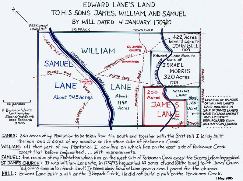
The tract appears to have contained about 2,993 acres (520
perches x 921 perches). Adding up the acres for land plotted, totals
about 2,947 acres (short about 46 acres). Samuel Lane has 945, William
Lane 1,145, Bull 122, Morris 320, James Lane 250, and William Lane's on
the east side of Skippack Creek 165.
Deed of Edmund and Ann (Lane) Cartledge and William Lane to Samuel Lane, dated 14 April 1724: Edmund Cartledge of Conestoga in the County of Chester in the Province of Pensilvania, yeoman, and Ann, his wife (she being formerly the Wife of Edward Lane of the County of Philadelphia, yeoman, deceased one of the Legates and an Executor named in the Last Will and Testament of the said Edward) and William Lane, eldest son and heir at law of the said Edward Lane, deceased, of the one part to Samuel Lane, another of the sons of the said Edward Lane, of the other part. This was for 630 acres which was part of Samuel Lane's inheritance but it did not include the 200 acres William Lane [120 on East side Perkiomen Creek] and Samuel Lane [80 on West side] sold to Peter Rambo 25 Jan 1722. Peter Rambo's will stated there was about 80 acres of land on the west side of the Perkiomen Creek which was part of Samuel's tract; however, when Peter Rambo's son sold to Henry Hall 13 Mar 1784, it was 60 ˝ acres. Adding up the various parcels Samuel or his Executors sold totals about 865 acres; adding the 80 acres to Peter Rambo equals about 945 acres.
(Phila. Co. Will Book C:200, 1710 will of Edward Lane; Phila. Co. Deed Books: F-5:362, Rec. 11 Dec 1731: to Samuel Lane, H-6:80, Rec. 11 Apr 1755: to Peter Rambo 200 acres; Phila. Will File 23-1753: 1744 will of Peter Rambo, proved 1753; Phila. Deed Book D-9:217, Rec. 3 Apr 1784: Peter Rambo to Henry Hall.)

Autumn along Perkiomen Creek
Deed of General Loan Office to Jacob Umsted, dated 3 March 1737. This refers to the mortgage default of James Lane's Administrator - thus the land came under the ownership of the General Loan Office. On 11 March 1729/30, James Lane mortgaged 335 acres of land, with a "Water Grist Mill," to the General Loan Office. Neither James Lane, nor his Administrator, Samuel Lane, paid the mortgage of 97 pounds 10 shillings with interest. Therefore, the General Loan Office sold the 335 acres with grist mill on 3 March 1737 to Jacob Umsted.
(Phila. Co. Mortgage Book 1724 Page 349 of the General Loan Office: James Lane; Phila. Co. Deed Book: H-4:480 Rec. 6 Aug 1754: General Loan Office to Jacob Umstatt, James Lane Estate Records.)
Deed of Edward Lane [son of William Lane] to Jacob Umstadt, dated 26 June 1746: Jacob Umstadt had to "re-purchase" from Edward Lane, son of William Lane, 85 acres of land which the General Loan Office had inadvertently included in the sale of James Lane's land. This 85 acres actually belonged to William Lane, who willed it to his son, Edward - James Lane owned 250 acres but had mortgaged 335 acres - which the General Loan Office sold to Jacob Umsted.
(Phila. Co. Deed Book: H-5:212: Rec. 6 Aug 1754.)
Jacob and Ann [Adams] Umstead sold about 50 of the above 85 acres bought from Edward Lane to Samuel Roberts by unrecorded deed. Samuel Roberts willed this land to his son Arnold in his will written 8 Apr 1793 with no description of his purchase of it. However, in 1820 when Arnold's land was sold by his widow and heirs the deed included the following statement, "Whereas Jacob Umstatt & Ann his wife by deed 2 May 1747 for a valuable consideration therein mentioned did grant and confirm unto Samuel Roberts in fee a certain Tract or piece of land therein particularly described situate in the Township of Providence aforesaid containing fifty acres more or less of land as by the said Indenture duly executed will appear By force and virtue of said conveyance or other sufficient assurances. . . ."
(Phila Co. Will book 2:22: will of Samuel Roberts; Mont. Co. Deed Book 43:477, history of land widow Mary Roberts et al. to Amos Pennypacker: Jacob Umstatt to Samuel Roberts 50 acres 1747.)
A key to the sale of the remainder of the 85 acres is found in the Deed of Jonathan and Elizabeth Meredith to Samuel Roberts, dated 5 February 1788. This deed for the sale of 29 acres to Samuel Roberts states, "A certain piece or tract of land situate in Providence Twp. ....... containing 29 acres and 24 perches of land (part of eighty five acres conveyed by Edward Lane and Ann his wife to Jacob Umsted) as in and by their Deed of release recorded at Philadelphia in Book H Vol. 5th page 212 Relation thereunto being had more at large will appear)". This land was sold to Jonathan Meredith by Rudolph and Sarah Bunner 1 December 1778. Possibly Jacob and Ann Umstatt sold this land to Rudolph Bunner but no deed has been located for the sale of this land prior to 1788. Samuel Roberts sold this land to Andrew Castleberry in 1811. Jacob and Ann Umstatt sold an adjacent tract of 50 acres to Samuel Roberts 2 May 1747. Deed plotting shows that the 50 acres and 29 acres were part of the 85 acres Jacob had to repurchase from Edward Lane, son of William Lane, in 1746.
(Mont. Co. Deed Book 5:250, history of land: 1788 Jonathan Meredith to Samuel Roberts.)
Deed of Edward Lane to William Couch, dated 1 January, 1785, 80 acres. (Mongtomery Co. Deed Book 1:62, recorded 17 Jan 1785.)
Israel Morris Land
Deed of Edward Lane's Executors to the sons and widow of Israel Morris, dated 10 April 1713, states that Edward Lane had given his executors the power to sell and dispose of all and every part of his estate, both real and personal, which had not been bequeathed, for the purpose of paying his debts and bringing up his children.
The Executors, James Shattick, Abraham Bickley and Ann Cartledge, now the wife of Edmund Cartledge of Philadelphia Co., yeoman, who was the widow of Edward Lane, now exercised their power to do so. They sold 320 acres of land to Israel Morris, Daniel Morris and John Morris, sons of Israel Morris, late of Philadelphia County, deceased, and Sarah, his wife, now the wife of Griffith Jones of the County, yeoman. Perhaps there was an agreement with Israel Morris before his decease to sell him this land. An Israel Morris [their father or kinsman] was a neighbor of Edward Lane in Bristol Twp. 1693.
(Phila. Deed Book E7-9:264, recorded 17 third month, 1716.)
It is the most mysterious of the Lane land records as there appears to be no extant deed that shows the later sale of it by the Morris family. This is what we do know: Administration of the estate of Israel Morris were issued to his widow Sarah Morris 10 Sep 1710. [This would indicate that all three of her sons were minors.] 7 Apr 1713 James Shattick, Abraham Bickley and Ann, widow of Edward Lane, now wife of Edmund Cartledge of Philadelphia County as executors of Edward Lane, deeded to Israel Morris [Jr.], Daniel Morris, and John Morris, the sons of Israel Morris, late of Philadelphia Co., deceased, and his widow Sarah Jones a tract of 320 acres adj. Harley's Twp. Sarah Morris, widow of Israel Sr., had remarried prior to that time to Griffith Jones of Skippack Twp., who d. in 1720 and left land to her and his children. Sarah d. 1721 when she willed, as widow of Griffith Jones, Skippack Twp., to her children Israel (under 21), John, and Daniel Morris and Ann, John and Mary Jones. There is no mention of the land sold to Israel Morris.
Morris Children: (1) Israel Morris m. Mary Adams, as she is listed as his widow in the 1746/7 will of her father Richard Adams. Other records show: An Israel Morris May 10, 1728 signed a petition, and in 1729 letters of administration were issued for an Israel Morris. He doesn't appear on the 1734 tax list nor on the 1736 St. James petition. (2) John Morris m. Catharine Adams, as she is listed as his widow in the 1746/7 will of her father Richard Adams. Other records show: A John Morris signed a petition in 1725 for the formation of Providence Twp., in 1734 was taxed on 80 A in Providence Twp., and in 1736 signed with Daniel Morris the St. James petition. There is no information on a remarriage or children of Mary (Adams) Morris nor of Catharine (Adams) Morris.
(Phila. Co. Will Book D:165, will of Israel Morris, D:185 will of Sarah Jones; "The Addams Family of America," by Addams S. McAllister, New York, a paper read at the Reunion of the Early Members of St. James P.E. Church of Perkiomen Montgomery County, Pa. June 4, 1921: HSMC Library.)
Bull Land
Deed of Richard Bull to John Bull, dated 29 May 1760, states Edward Lane sold 122 acres to John Bull on 25th day of 1st month called March 1709.
(Phila. Co. Deed Book H-14:488. recorded 13 Feb 1762, History of Land.)
Church Land
William Lane's will states: "Item I do hereby give & bequeath for the use of the ministers that shall serve successively at St. James Church situate in Providence about forty two acres of land adjoining thereunto Church Land shall be laid out as Commodious for a settlement as conveniently it may without causing much damage to the remaining part of my land, And the abovesd. Forty two acres of Land, Message, Tenement, Hereditaments, appurtenances & improvements whatsoever shall be & continuously by Virtue hereof to & for the use abovesd. from the Day of my decease thenceforward forever.' The actual deed was for forty acres.
Deed from Samuel Lane and Henry Pawling, Executors of William Lane to Jonathan Woodley, Peter Rambo and Stephen Bowyer [St. James Vestrymen], dated 3 April 1737, quotes William's will and says he bequeathed to the church forty acres of land. This deed is for forty acres or thereabouts.
(Phila. Co. Deed Book F-10:326.)
Old Mill Race
Grist Mill Note:
Theodore W. Bean, editor, History of Montgomery County, Pennsylvania. Page 105 says Edward Lane had a grist mill on the Perkiomen, near stone bridge, in 1708. Page 1047 states he [Edward Lane] erected a grist-mill on the Skippack in 1708. A careful analysis of Edward Lane's will shows that the mill mentioned in his will was built on the Skippack Creek. Deeds tracing the history of this land verify this. Edward Lane did not build a mill on the Perkiomen Creek. Deed research of Edward's land on both sides of the Perkiomen Creek finds no mention of a mill until a deed dated 14 April 1807 when William and Abigail Couch sold to Daniel Haus thirty acres of land with "mills".
It is believed that William Couch built the Collegeville Mill sometime between 1791 (after he sold his 80 acre property at the other end of the Lane tract) and 1793. In 1791, Couch is taxed on 124 acres, no mill mentioned. The 1792 tax records do not list acres or occupations. In 1793 he is taxed as a miller with 150 acres, 1 grist mill, 80 acres abated. In 1794 William Couch purchased 110 acres, formerly the land of John Reed, and 68 acres in 4 tracts from William Rittenhouse, formerly the land of Detrick Welker. The 1794 and 1795 tax records are missing. By 1796, tax records show William Couch with a grist mill and a saw mill.
(Theodore W. Bean, editor, History of Montgomery County, Pennsylvania, Phila.: Everts & Peck, 1884; Mont. Co. Sheriff Book B:43, Reed by Sheriff to Couch, 14 May 1794; Mont. Co. Deed Book 7:887, Rittenhouse to Couch, 5 Jul 1794.)
Deed of William and Abigail Couch to Daniel Haus 14 Apr 1807, "....containing thirty acres of land which the above named William Couch and Abigail his wife by their Indenture bearing date the fourteenth day of April Anno Domi 1807 for the consideration therein mentioned did grant and confirm unto the said Daniel Haus and his heirs and assigns to hold to him the said Daniel Haus and to his heirs and assigns forever amen and by the said recited indenture duly executed and acknowledged relation being thereunto has at large appears with all and singular the houses, out houses, mills, barns, stables, ways woods waters, water courses sluices races, dams rights liberties privileges hereditaments promises and appurtances whatsoever thereunto belonging or in any wise appertaining and the reversion and remainder rents issues and profits thereon...."
(Mont. Co. Deed Book 29:323.)
Deed of Edmund and Ann (Lane) Cartledge and William Lane to Samuel Lane, dated 14 April 1724: Edmund Cartledge of Conestoga in the County of Chester in the Province of Pensilvania, yeoman, and Ann, his wife (she being formerly the Wife of Edward Lane of the County of Philadelphia, yeoman, deceased one of the Legates and an Executor named in the Last Will and Testament of the said Edward) and William Lane, eldest son and heir at law of the said Edward Lane, deceased, of the one part to Samuel Lane, another of the sons of the said Edward Lane, of the other part. This was for 630 acres which was part of Samuel Lane's inheritance but it did not include the 200 acres William Lane [120 on East side Perkiomen Creek] and Samuel Lane [80 on West side] sold to Peter Rambo 25 Jan 1722. Peter Rambo's will stated there was about 80 acres of land on the west side of the Perkiomen Creek which was part of Samuel's tract; however, when Peter Rambo's son sold to Henry Hall 13 Mar 1784, it was 60 ˝ acres. Adding up the various parcels Samuel or his Executors sold totals about 865 acres; adding the 80 acres to Peter Rambo equals about 945 acres.
(Phila. Co. Will Book C:200, 1710 will of Edward Lane; Phila. Co. Deed Books: F-5:362, Rec. 11 Dec 1731: to Samuel Lane, H-6:80, Rec. 11 Apr 1755: to Peter Rambo 200 acres; Phila. Will File 23-1753: 1744 will of Peter Rambo, proved 1753; Phila. Deed Book D-9:217, Rec. 3 Apr 1784: Peter Rambo to Henry Hall.)
Autumn along Perkiomen Creek
Deed of General Loan Office to Jacob Umsted, dated 3 March 1737. This refers to the mortgage default of James Lane's Administrator - thus the land came under the ownership of the General Loan Office. On 11 March 1729/30, James Lane mortgaged 335 acres of land, with a "Water Grist Mill," to the General Loan Office. Neither James Lane, nor his Administrator, Samuel Lane, paid the mortgage of 97 pounds 10 shillings with interest. Therefore, the General Loan Office sold the 335 acres with grist mill on 3 March 1737 to Jacob Umsted.
(Phila. Co. Mortgage Book 1724 Page 349 of the General Loan Office: James Lane; Phila. Co. Deed Book: H-4:480 Rec. 6 Aug 1754: General Loan Office to Jacob Umstatt, James Lane Estate Records.)
Deed of Edward Lane [son of William Lane] to Jacob Umstadt, dated 26 June 1746: Jacob Umstadt had to "re-purchase" from Edward Lane, son of William Lane, 85 acres of land which the General Loan Office had inadvertently included in the sale of James Lane's land. This 85 acres actually belonged to William Lane, who willed it to his son, Edward - James Lane owned 250 acres but had mortgaged 335 acres - which the General Loan Office sold to Jacob Umsted.
(Phila. Co. Deed Book: H-5:212: Rec. 6 Aug 1754.)
Jacob and Ann [Adams] Umstead sold about 50 of the above 85 acres bought from Edward Lane to Samuel Roberts by unrecorded deed. Samuel Roberts willed this land to his son Arnold in his will written 8 Apr 1793 with no description of his purchase of it. However, in 1820 when Arnold's land was sold by his widow and heirs the deed included the following statement, "Whereas Jacob Umstatt & Ann his wife by deed 2 May 1747 for a valuable consideration therein mentioned did grant and confirm unto Samuel Roberts in fee a certain Tract or piece of land therein particularly described situate in the Township of Providence aforesaid containing fifty acres more or less of land as by the said Indenture duly executed will appear By force and virtue of said conveyance or other sufficient assurances. . . ."
(Phila Co. Will book 2:22: will of Samuel Roberts; Mont. Co. Deed Book 43:477, history of land widow Mary Roberts et al. to Amos Pennypacker: Jacob Umstatt to Samuel Roberts 50 acres 1747.)
A key to the sale of the remainder of the 85 acres is found in the Deed of Jonathan and Elizabeth Meredith to Samuel Roberts, dated 5 February 1788. This deed for the sale of 29 acres to Samuel Roberts states, "A certain piece or tract of land situate in Providence Twp. ....... containing 29 acres and 24 perches of land (part of eighty five acres conveyed by Edward Lane and Ann his wife to Jacob Umsted) as in and by their Deed of release recorded at Philadelphia in Book H Vol. 5th page 212 Relation thereunto being had more at large will appear)". This land was sold to Jonathan Meredith by Rudolph and Sarah Bunner 1 December 1778. Possibly Jacob and Ann Umstatt sold this land to Rudolph Bunner but no deed has been located for the sale of this land prior to 1788. Samuel Roberts sold this land to Andrew Castleberry in 1811. Jacob and Ann Umstatt sold an adjacent tract of 50 acres to Samuel Roberts 2 May 1747. Deed plotting shows that the 50 acres and 29 acres were part of the 85 acres Jacob had to repurchase from Edward Lane, son of William Lane, in 1746.
(Mont. Co. Deed Book 5:250, history of land: 1788 Jonathan Meredith to Samuel Roberts.)
Deed of Edward Lane to William Couch, dated 1 January, 1785, 80 acres. (Mongtomery Co. Deed Book 1:62, recorded 17 Jan 1785.)
Israel Morris Land
Deed of Edward Lane's Executors to the sons and widow of Israel Morris, dated 10 April 1713, states that Edward Lane had given his executors the power to sell and dispose of all and every part of his estate, both real and personal, which had not been bequeathed, for the purpose of paying his debts and bringing up his children.
The Executors, James Shattick, Abraham Bickley and Ann Cartledge, now the wife of Edmund Cartledge of Philadelphia Co., yeoman, who was the widow of Edward Lane, now exercised their power to do so. They sold 320 acres of land to Israel Morris, Daniel Morris and John Morris, sons of Israel Morris, late of Philadelphia County, deceased, and Sarah, his wife, now the wife of Griffith Jones of the County, yeoman. Perhaps there was an agreement with Israel Morris before his decease to sell him this land. An Israel Morris [their father or kinsman] was a neighbor of Edward Lane in Bristol Twp. 1693.
(Phila. Deed Book E7-9:264, recorded 17 third month, 1716.)
It is the most mysterious of the Lane land records as there appears to be no extant deed that shows the later sale of it by the Morris family. This is what we do know: Administration of the estate of Israel Morris were issued to his widow Sarah Morris 10 Sep 1710. [This would indicate that all three of her sons were minors.] 7 Apr 1713 James Shattick, Abraham Bickley and Ann, widow of Edward Lane, now wife of Edmund Cartledge of Philadelphia County as executors of Edward Lane, deeded to Israel Morris [Jr.], Daniel Morris, and John Morris, the sons of Israel Morris, late of Philadelphia Co., deceased, and his widow Sarah Jones a tract of 320 acres adj. Harley's Twp. Sarah Morris, widow of Israel Sr., had remarried prior to that time to Griffith Jones of Skippack Twp., who d. in 1720 and left land to her and his children. Sarah d. 1721 when she willed, as widow of Griffith Jones, Skippack Twp., to her children Israel (under 21), John, and Daniel Morris and Ann, John and Mary Jones. There is no mention of the land sold to Israel Morris.
Morris Children: (1) Israel Morris m. Mary Adams, as she is listed as his widow in the 1746/7 will of her father Richard Adams. Other records show: An Israel Morris May 10, 1728 signed a petition, and in 1729 letters of administration were issued for an Israel Morris. He doesn't appear on the 1734 tax list nor on the 1736 St. James petition. (2) John Morris m. Catharine Adams, as she is listed as his widow in the 1746/7 will of her father Richard Adams. Other records show: A John Morris signed a petition in 1725 for the formation of Providence Twp., in 1734 was taxed on 80 A in Providence Twp., and in 1736 signed with Daniel Morris the St. James petition. There is no information on a remarriage or children of Mary (Adams) Morris nor of Catharine (Adams) Morris.
(Phila. Co. Will Book D:165, will of Israel Morris, D:185 will of Sarah Jones; "The Addams Family of America," by Addams S. McAllister, New York, a paper read at the Reunion of the Early Members of St. James P.E. Church of Perkiomen Montgomery County, Pa. June 4, 1921: HSMC Library.)
Bull Land
Deed of Richard Bull to John Bull, dated 29 May 1760, states Edward Lane sold 122 acres to John Bull on 25th day of 1st month called March 1709.
(Phila. Co. Deed Book H-14:488. recorded 13 Feb 1762, History of Land.)
Church Land
William Lane's will states: "Item I do hereby give & bequeath for the use of the ministers that shall serve successively at St. James Church situate in Providence about forty two acres of land adjoining thereunto Church Land shall be laid out as Commodious for a settlement as conveniently it may without causing much damage to the remaining part of my land, And the abovesd. Forty two acres of Land, Message, Tenement, Hereditaments, appurtenances & improvements whatsoever shall be & continuously by Virtue hereof to & for the use abovesd. from the Day of my decease thenceforward forever.' The actual deed was for forty acres.
Deed from Samuel Lane and Henry Pawling, Executors of William Lane to Jonathan Woodley, Peter Rambo and Stephen Bowyer [St. James Vestrymen], dated 3 April 1737, quotes William's will and says he bequeathed to the church forty acres of land. This deed is for forty acres or thereabouts.
(Phila. Co. Deed Book F-10:326.)
Old Mill Race
Grist Mill Note:
Theodore W. Bean, editor, History of Montgomery County, Pennsylvania. Page 105 says Edward Lane had a grist mill on the Perkiomen, near stone bridge, in 1708. Page 1047 states he [Edward Lane] erected a grist-mill on the Skippack in 1708. A careful analysis of Edward Lane's will shows that the mill mentioned in his will was built on the Skippack Creek. Deeds tracing the history of this land verify this. Edward Lane did not build a mill on the Perkiomen Creek. Deed research of Edward's land on both sides of the Perkiomen Creek finds no mention of a mill until a deed dated 14 April 1807 when William and Abigail Couch sold to Daniel Haus thirty acres of land with "mills".
It is believed that William Couch built the Collegeville Mill sometime between 1791 (after he sold his 80 acre property at the other end of the Lane tract) and 1793. In 1791, Couch is taxed on 124 acres, no mill mentioned. The 1792 tax records do not list acres or occupations. In 1793 he is taxed as a miller with 150 acres, 1 grist mill, 80 acres abated. In 1794 William Couch purchased 110 acres, formerly the land of John Reed, and 68 acres in 4 tracts from William Rittenhouse, formerly the land of Detrick Welker. The 1794 and 1795 tax records are missing. By 1796, tax records show William Couch with a grist mill and a saw mill.
(Theodore W. Bean, editor, History of Montgomery County, Pennsylvania, Phila.: Everts & Peck, 1884; Mont. Co. Sheriff Book B:43, Reed by Sheriff to Couch, 14 May 1794; Mont. Co. Deed Book 7:887, Rittenhouse to Couch, 5 Jul 1794.)
Deed of William and Abigail Couch to Daniel Haus 14 Apr 1807, "....containing thirty acres of land which the above named William Couch and Abigail his wife by their Indenture bearing date the fourteenth day of April Anno Domi 1807 for the consideration therein mentioned did grant and confirm unto the said Daniel Haus and his heirs and assigns to hold to him the said Daniel Haus and to his heirs and assigns forever amen and by the said recited indenture duly executed and acknowledged relation being thereunto has at large appears with all and singular the houses, out houses, mills, barns, stables, ways woods waters, water courses sluices races, dams rights liberties privileges hereditaments promises and appurtances whatsoever thereunto belonging or in any wise appertaining and the reversion and remainder rents issues and profits thereon...."
(Mont. Co. Deed Book 29:323.)
Return to Lane Land Tract Maps