Pennsylvania USGenWeb Archives

Montgomery County
|
|
|
|


[an error occurred while processing this directive]
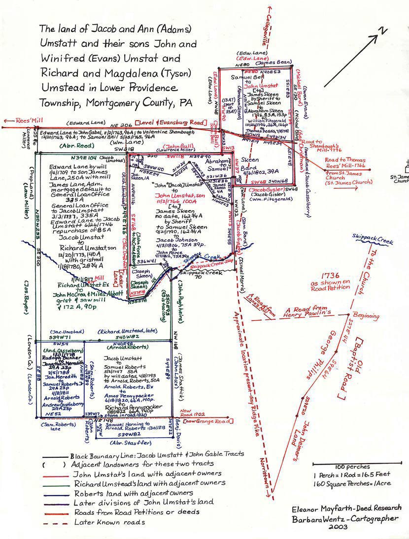
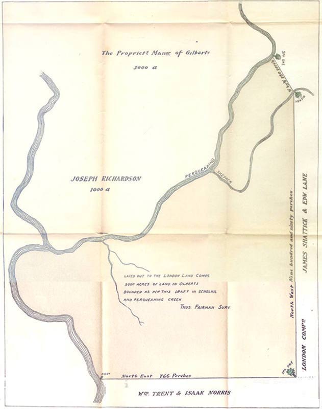
MAP 6: Umstat, Roberts, and Skeen Notes and References
ROADS
Road Return, dated 19 December 1766, "Road from St. James Church to Thomas Rees' Mill." This road runs between the church land and land of Jacob Goisler, through the land of John Umstadt and John Bull, and between John Bull and Edward Lane.
(Philadelphia City Archives, Packet 29:186, 1766.)
Road Petitions, Providence Road to and from Lane's Mill, Providence to Norriton, 1734/36. This road travels through George Phillips' land and begins at a road reserved by Edward Lane [pre 1710] for the accommodation of his Mill on Skippack Creek in that part thereof which is confirmed leading from Henry Pawlin's to the Church. This is Old Baptist Road.
(Road Petition Book 1, p. 118, HSMC.)
Deed of Samuel Roberts to John Loucks, dated 23 April 1818. This deed for a property adjacent to Samuel Roberts and John Umstat's land (and adjacent to land which earlier was the land of William Couch) refers to a new road – now Grange Avenue. This verified the correct placement of Jacob Umstat's land from James Lane and Edward Lane.
(Mont. Co. Deed Book 35:136, Rec. 29 May 1818.)
JACOB UMSTAT'S LAND
Edward Lane's will of 1710 states, "I give unto my Son James, To him his heirs, Execs., Adminis., Assignees forever two hundred and fifty acres of my plantation to be taken from the south end thereof, Together with the grist Mill the Testator built thereon".
(Phila. Co. Will Book, C:200, 1710 will of Edward Lane.)
Deed of General Loan Office to Jacob Umsted, dated 3 March 1737, refers to the mortgage default of James Lane's Administrator – thus the land came under the ownership of the General Loan Office. On 11 March 1729/30, James Lane mortgaged 335 acres of land, with a "Water Grist Mill," to the General Loan Office. Neither James Lane, nor his Administrator, Samuel Lane, paid the mortgage of 97 pounds 10 shillings with interest. Therefore, the General Loan Office sold the 335 acres with grist mill on 3 March 1737 to Jacob Umsted.
(Phila. Co. Deed Book, H-4:480, Rec. 6 Aug 1754; Duffin, James M., Guide to the Mortgages of the General Loan Office of the Province of Pennsylvania, 1724-1756, 17 which refers to Phila. Co. Mortgage Book 1724:349: "which was for 335 acres and not satisfied.")
Deed of Edward Lane [son of William Lane] to Jacob Umstadt, dated 26 June 1746: Jacob Umstadt had to "re-purchase" from Edward Lane, son of William Lane, 85 acres of land which the General Loan Office had inadvertently included in the sale of James Lane's land. These 85 acres actually belonged to William Lane, who willed it to his son, Edward – James Lane owned 250 acres but had mortgaged 335 acres – which the General Loan Office sold to Jacob Umsted.
(Phila. Co. Deed Book H-5-212, Rec. 6 Aug 1754.)
Samuel Roberts' Section of Jacob Umstat's 85 acres from Edward Lane 1746
History of Roberts Land in Providence Township:
7th day of March 1713/4. James Shattick sold to Edward Roberts 150 acres, adjacent to the land that was to become the land of Jacob Umstat on one side, and to the land that was to become "The London Co. Tract" on the other side. Samuel Roberts Sr. who married Katherine Francis 8 mo. 1, 1740, inherited the 150 acres from his father in 1753. By the time of his death in 1797 Samuel Sr. had purchased two additional tracts of land:
(1) In 1747 50 acres from Jacob Umstat, not adjacent to his own land, part of 85 acres. (Unrecorded Deed)
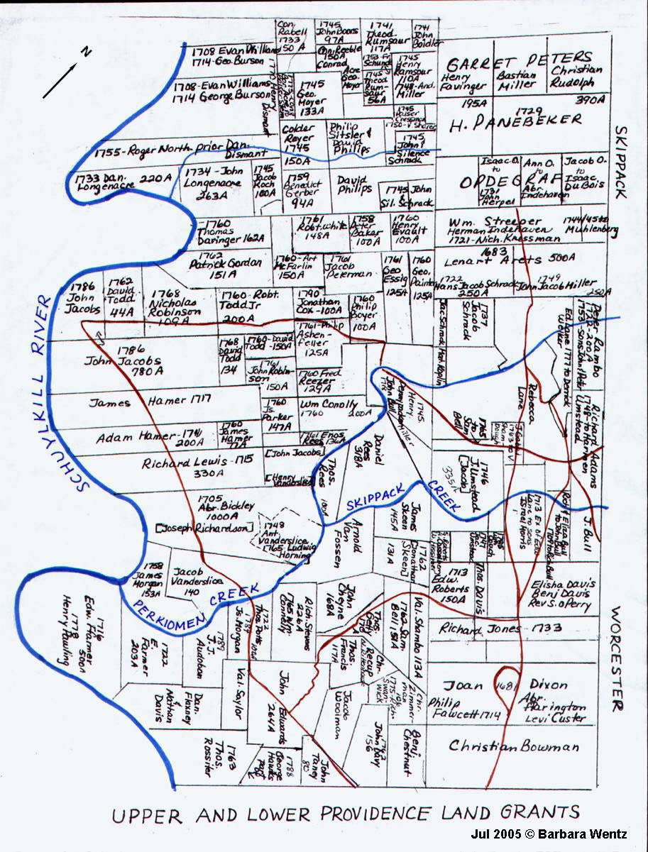
(2) In 1763 131 acres + of the land that Jonathan Skeen had purchased from the London Company, adjacent to Samuel's own 150 acres. SEE MAP, Upper and Lower Providence Land Grants
(Phila. Co. Deed Book E-7 10:1, James Shattick to Edward Roberts; Phila. Co. Will Book K:32 #22: 1748 will of Edward Roberts, no wife mentioned ; PA. AR.7, Records of 1st Presbyterian Church, Philadelphia: Samuel Roberts and Katharine Francis; Mont. Co. Deed Book 43:477, Mary Roberts, et al to Amos Pennypacker, Rec. 17 Mar 1828: History of Land; Mont. Co. Deed Book 323:172, Jonathan Skeen to Samuel Roberts, Rec. 14 Apr 1888: History of Land; Mont. Co. Will Book 2:22, 1793 will of Samuel Roberts [Sr.); Mont. Co. Estate File RW5620 , OC15992, includes Estate Papers of Samuel Roberts and Samuel Jr.)
Finding Jacob Umstead's 85 acres from "History of Land" in Land Deeds
Arnold Roberts died intestate leaving 2 sons and 4 daughters.
Deed of Mary Roberts, et al, to Amos Pennypacker, dated 18 June 1820. Mary, widow of Arnold, Andrew Casselberry, sadler, & Elizabeth, Samuel Roberts of Phila., John Roberts of L. Prov., Jacob Highley & Sarah, L. Prov., Richard Pennypacker & Catherine of L. Prov, and Daniel Tyson & Mary of U. Providence sell to Amos Pennypacker 2 Tracts of land totaling 66 acres, 140 perches.
Tract 1: "Whereas Jacob Umstatt & Ann his wife by deed 2 May 1747 for a valuable consideration therein mentioned did grant and confirm unto Samuel Roberts in fee a certain Tract or piece of land therein particularly described situate in the Township of Providence aforesaid containing fifty acres more or less of land as by the said Indenture duly executed will appear By force and virtue of said conveyance or other sufficient assurances. . . Beginning stone in corner of public road, also a corner of Andrew Casselberry and adj. to land of late Richard Umstead, John Loux, Benjamin Davis, Abraham Stouffer, and John Roberts. . ."
Tract 2: Samuel Horning, 30 January 1813, to Arnold Roberts, 11 acres, 115 perches, subject to dower of Lydia Roberts, adjacent to Tract 1. [This land is outside the Lane Tract].
(Mont. Co. Deed Book 43:477, Rec. 17 Mar 1828.)
The remainder of the 85 acres of Jacob Umstat:
Deed of Jonathan and Elizabeth Meredith to Samuel Roberts [Jr.] dated 5 February 1788, for the sale of 29 acres to Samuel Roberts states, "A certain piece or tract of land situate in Providence Twp. . . . . containing 29 acres and 24 perches of land (part of eighty five acres conveyed by Edward Lane and Ann his wife to Jacob Umsted) as in and by their Deed of release recorded at Philadelphia in Book H Vol. 5th page 212 Relation thereunto being had more at large will appear)". This land was sold to Jonathan Meredith by Rudolph and Sarah Bunner 1 December 1778. Possibly Jacob and Ann Umstatt sold this land to Rudolph Bunner but no deed has been located for the sale of this land prior to 1788. This land is adjacent to the 50 acres sold by Jacob and Ann Umstatt to Samuel Roberts Sr. above. Deed plotting shows that the 50 acres and 29 acres were part of the 85 acres Jacob had to repurchase from Edward Lane, son of William Lane, in 1746.
(Mont. Co. Deed Book 5:250.)
Deed of Arnold Roberts to Andrew Castleberry, dated 8 April 1811, 29 acres, 23 perches which Jonathan Meredith sold to Samuel Roberts Jr.
(Mont. Co. Deed Book 29:15)
Deed of Amos Pennypacker to Richard Pennypacker, dated 18 January 1822, 66 acres 140 perches. [And so the 50 acres returned to the family of Jacob and Ann Umstat, Richard Pennypacker being the son of Jacob Pennypacker and Hannah (Umstat), dau. of Jacob and Ann.
(Mont. Co. Deed Book 43:480, Rec. 17 Mar 1828.)
[And so in 1820 the 50 acres sold to Samuel Roberts Sr. by Jacob and Ann Umstat in 1747 returned to the family of Jacob and Ann, Amos and Richard Pennypacker being the sons of Jacob Pennypacker and Hannah (Umstat), dau. of Jacob and Ann.] Richard Umstead's Section of Jacob Umstat's Land
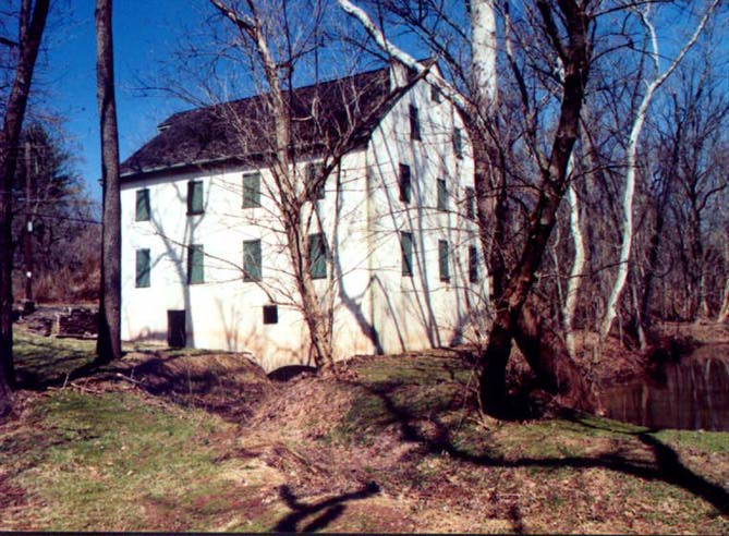
Deed of Jacob Umstat [brother of Richard] and Michael Corbitt (Executors of Richard Umstat) to John McCrea and Miles Abbott, dated 14 April 1817, states Jacob Umstat and his wife Ann by indenture under their hands and seal bearing date 20 December 1773 for the same plantation herein named sold Richard Umstat a tract of land with a water grist mill thereon in Providence, now Lower Providence, containing 140 acres [not recorded]. And whereas sd. Jacob and Ann by indenture dated 13 January 1780 sold him a tract adjacent to aforementioned containing 28 and 3/4 acres [not recorded]. New survey has been made and contains 172 acres and 90 square perches.
(Mont. Co. Deed Book 34:107.)
Deed of Miles Abbott to John McCrea, dated 4 June 1818, 21 acres, 101 perches, part of Richard Umstead's 172 acres.
(Mont. Co. Deed Book 35:200.)
AND THE MILL CONTINUED
October 2, 1838:
Wm. L. Evans announces that his Grist Mill in Lower Providence is in operation on the Skippack,
at the place the late Richard Umstead carried on milling for many years. Wheat and Rye flour will
be kept on hand for sale.
(Meier28 Volume IV, 1833-1838, p. 177.)
"Evans G. Mills" is on the 1848 Montgomery County map. Since the above advertisement is quite
a time after Richard Umstead's death, his mill must have been very well known.
1850 census: William Evans, 50, farmer, real estate of $2,500, Barbara, 50, William C., 21, miller,
no real estate, and Ellen, 18.
1860 census: William C. Evans, 33, miller, real estate $3,500, Boanna [sic], 23, William J., 1.
"Along the Perkiomen in the Former Gilbert's Manor", by Joseph Shrawder
Bulletin of the HSMC, Volume XX No. 1 (Fall 1975): 81.
(Mr. Shrawder died 1959 in his 85th year.)
Keyser's Mill
1871 map of Lower Providence shows H. V. Johnson living opposite G. Mill; 1877 map shows J. Shrawder opposite G.M. (relationship to the author of the above article not known); 1893 map shows G.M. on the other side of the Skippack Creek and the house of Mathilde Curdy where the mill stood, which seems to be an error.
1870 Census: H. V. Johnson, 37, miller, Real Estate $6,000, Personal Property $1,000, with a wife and 2 children; also F. Pierce Reed, 17, apprentice to miller and Wm. R. Hallman, 18, apparently also an apprentice to miller.
"David Whitworth" is likely David Wolworth, 30, miller, in the 1880 census with wife Sarah, 30, and daughter Annie M., age 10.
John Umstat's Section of Jacob Umstat's Land
Mortgage of John Umstat to Hugh Roberts, dated 27 July 1768, satisfied 7 December 1771. Tract 1: 62 plus acres, formerly the land of Jacob Gyslers/Geislers/Goislers, sold to John Umstat by Samuel and Sarah Boll [Bell] 5 June 1766 [not recorded]. Tract 2: 100 acres "being the same tract which John [Jacob] Umstat and Ann the father and mother of the sd. John Umstat did grant unto the sd. John Umstat. . . 28 November 1766" [not recorded]. A note on John Umstat's mortgage in this mortgage book says the mortgage to Hugh Roberts was renewed by James Skeen on the same lands 15 November 1770.
(Phila. Co. Mortgage Book X-13:169.)
Francis Swaine, Sheriff, to Samuel Skeene [Skeen], 13 October 1790. Taken in Execution of suit of George Roberts & Heirs of Hugh Roberts. Two tracts of land. Tract 1: 62 ľ acres. Tract 2: 100 acres.
George Roberts (Executor of Hugh Roberts) vs. James Skeen. Debt 200 pounds.
"And now to wit the thirteenth of October in the year of our Lord one thousand seven hundred and ninety Francis Swaine Esquire high Sheriff of County of Montgomery Acknowledges in open Court a Deed Poll under his hand Seal bearing Date the twenty first day of September in the Year of our Lord one thousand seven hundred and ninety conveying unto Samuel Skeene." (Mont. Co. Sheriff Book A:74.)
Deed of Samuel Skeen to Jacob Johnson, dated 3 April 1806. 75 acres 39 perches. This deed states:
Deed of Jacob Johnson to John Force, dated 7 April 1812. 75 acres, 30 [39?] perches. Same Samuel Skeen sold to Jacob Johnson, 3 April 1806.
(Montgomery Co. Deed Book 29:56.)
(Mont. Co. Deed Book 35:196, Rec. 9 Jul 1818.)
Deed of John Force to John McCrea and Miles Abbott, dated 14 April 1817, 53 acres, 146 perches, remaining part of 75 acres, 30 perches from Jacob Johnson, 17 April 1812.
(Mont. Co. Deed Book 35: 198, Rec. 9 Jul 1818.)
Deed of Abraham Skeen to Samuel Bard, dated 6 April 1802, 39 acres, part of 83 acres, 153 perches Samuel Skeen sold to Abraham 19 September 1796 [not recorded]. This land includes part of the land John Umstat purchased from Samuel Bell and part of the land he received from his father, Jacob Umstat.
(Mont. Co. Deed Book 21:305, Rec. 27 Jan 1806.)
Deed of Abraham Skeen to James Skeen and Joseph Skeen, dated 16 November 1802. To James Skeen one tract of 4 acres; to Joseph Skeen one tract of 1 acre. Both lots part of 83 acres, 153 perches Samuel Skeen sold to Abraham 19 September 1796 [not recorded].
(Mont. Co. Deed Book 24:61.)
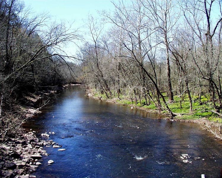
Along the Skippack
Deed of Elijah and Sarah Skeen to John Heiser, dated 2 April 1829, 10 acres. Jan. 2, 1808: Whereas Samuel Skeen & Jemima did grant & confirm to Joseph Skeen a certain Messuage containing 10 A more or less with Appurtences. Unrecorded land record in the "History of the Land" in 1829 sale when Elijah and Sarah (Heiser) Skeen sell to Sarah's brother John Heiser, 10 acres adj. to land of Richard Umstat, dec., and along west side of Skippack Creek. Land in possession of Joseph Skeen when he died intestate, and in 1829 decreed by court as land of eldest son Elijah.
(Mont. Co. Deed Book 142:335, Rec. 4 Apr 1866.)
John Umstat's land from Samuel Bell
Deed of Edward and Ann Lane to John Gabel, dated 2 Nov 1763, 96 acres.
(Phila. Co. Deed Book I-5:210, Rec. 16 Dec 1768.)
Deed of John Gabel to Valentine Shambough, dated 20 Dec 1763, 96 acres.
(Phila. Co. Deed Book I-5:211, Rec. 16 Dec 1768.)
Deed of Valentine Shambough to Samuel Bell, dated 25 May 1765, 96 acres.
(Phila. Co. Deed Book I-4:458, Rec. 9 Aug 1768.)
Mortgage of John Umstat to Hugh Roberts, dated 27 July 1768, satisfied 7 December 1771. Tract 1: 62 plus acres, formerly the land of Jacob Gyslers/Geislers/Goislers, sold to John Umstat by Samuel and Sarah Boll [Bell] 5 June 1766 [not recorded]. Tract 2: 100 acres "being the same tract which John [Jacob] Umstat and Ann the father and mother of the sd. John Umstat did grant unto the sd. John Umstat. . .28 November 1766"[not recorded]. A note on John Umstat's mortgage in this mortgage book says the mortgage to Hugh Roberts was renewed by James Skeen on the same lands 15 November 1770.
(Phila. Co. Mortgage Book X-13:169.)
Francis Swaine, Sheriff, to Samuel Skeene [Skeen], 13 October 1790. Taken in Execution of suit of George Roberts & Heirs of Hugh Roberts. Two tracts of land. Tract 1: 62 ľ acres. Tract 2: 100 acres.
(Mont. Co. Sheriff Book A:74.)
(Mont. Co. Deed Book 10:55, Rec. 15 Nov 1796.)
Deed of William Fitzgerald to Thomas Deeds, dated 8 July 1799, 26 acres, 126 perches. This land is adjacent to Abraham Skeen who apparently still owned about 13 acres remaining of the 83 acres, 153 perches which Abraham purchased from Samuel Skeen [not recorded]. The road to Shambough's Mill is one of the boundaries of this property.
(Mont. Co. Deed Book 12:496.)
Deed of Abraham Skeen to Samuel Bard, dated 6 Apr 1802, 39 acres, part of 83 acres, 153 perches Samuel Skeen sold to Abraham 19 Sep 1796 [not recorded]. This land includes part of the land John Umstat purchased from Samuel Bell and part of the land he received from his father, Jacob Umstat.
(Mont. Co. Deed Book 21:305, Rec. 27 Jan 1806.)
Except for the 3 years between Richard Umstat's death and when Amos Pennypacker, grandson of Jacob and Ann Umstead, purchased the land of Arnold Roberts, the Umstats lived on the land for at least 100 years.
Return to Lane Land Tract Maps
Road Return, dated 19 December 1766, "Road from St. James Church to Thomas Rees' Mill." This road runs between the church land and land of Jacob Goisler, through the land of John Umstadt and John Bull, and between John Bull and Edward Lane.
(Philadelphia City Archives, Packet 29:186, 1766.)
Road Petitions, Providence Road to and from Lane's Mill, Providence to Norriton, 1734/36. This road travels through George Phillips' land and begins at a road reserved by Edward Lane [pre 1710] for the accommodation of his Mill on Skippack Creek in that part thereof which is confirmed leading from Henry Pawlin's to the Church. This is Old Baptist Road.
(Road Petition Book 1, p. 118, HSMC.)
Deed of Samuel Roberts to John Loucks, dated 23 April 1818. This deed for a property adjacent to Samuel Roberts and John Umstat's land (and adjacent to land which earlier was the land of William Couch) refers to a new road – now Grange Avenue. This verified the correct placement of Jacob Umstat's land from James Lane and Edward Lane.
(Mont. Co. Deed Book 35:136, Rec. 29 May 1818.)
JACOB UMSTAT'S LAND
Edward Lane's will of 1710 states, "I give unto my Son James, To him his heirs, Execs., Adminis., Assignees forever two hundred and fifty acres of my plantation to be taken from the south end thereof, Together with the grist Mill the Testator built thereon".
(Phila. Co. Will Book, C:200, 1710 will of Edward Lane.)
Deed of General Loan Office to Jacob Umsted, dated 3 March 1737, refers to the mortgage default of James Lane's Administrator – thus the land came under the ownership of the General Loan Office. On 11 March 1729/30, James Lane mortgaged 335 acres of land, with a "Water Grist Mill," to the General Loan Office. Neither James Lane, nor his Administrator, Samuel Lane, paid the mortgage of 97 pounds 10 shillings with interest. Therefore, the General Loan Office sold the 335 acres with grist mill on 3 March 1737 to Jacob Umsted.
(Phila. Co. Deed Book, H-4:480, Rec. 6 Aug 1754; Duffin, James M., Guide to the Mortgages of the General Loan Office of the Province of Pennsylvania, 1724-1756, 17 which refers to Phila. Co. Mortgage Book 1724:349: "which was for 335 acres and not satisfied.")
Deed of Edward Lane [son of William Lane] to Jacob Umstadt, dated 26 June 1746: Jacob Umstadt had to "re-purchase" from Edward Lane, son of William Lane, 85 acres of land which the General Loan Office had inadvertently included in the sale of James Lane's land. These 85 acres actually belonged to William Lane, who willed it to his son, Edward – James Lane owned 250 acres but had mortgaged 335 acres – which the General Loan Office sold to Jacob Umsted.
(Phila. Co. Deed Book H-5-212, Rec. 6 Aug 1754.)
Samuel Roberts' Section of Jacob Umstat's 85 acres from Edward Lane 1746
History of Roberts Land in Providence Township:
7th day of March 1713/4. James Shattick sold to Edward Roberts 150 acres, adjacent to the land that was to become the land of Jacob Umstat on one side, and to the land that was to become "The London Co. Tract" on the other side. Samuel Roberts Sr. who married Katherine Francis 8 mo. 1, 1740, inherited the 150 acres from his father in 1753. By the time of his death in 1797 Samuel Sr. had purchased two additional tracts of land:
(1) In 1747 50 acres from Jacob Umstat, not adjacent to his own land, part of 85 acres. (Unrecorded Deed)
(2) In 1763 131 acres + of the land that Jonathan Skeen had purchased from the London Company, adjacent to Samuel's own 150 acres. SEE MAP, Upper and Lower Providence Land Grants
(Phila. Co. Deed Book E-7 10:1, James Shattick to Edward Roberts; Phila. Co. Will Book K:32 #22: 1748 will of Edward Roberts, no wife mentioned ; PA. AR.7, Records of 1st Presbyterian Church, Philadelphia: Samuel Roberts and Katharine Francis; Mont. Co. Deed Book 43:477, Mary Roberts, et al to Amos Pennypacker, Rec. 17 Mar 1828: History of Land; Mont. Co. Deed Book 323:172, Jonathan Skeen to Samuel Roberts, Rec. 14 Apr 1888: History of Land; Mont. Co. Will Book 2:22, 1793 will of Samuel Roberts [Sr.); Mont. Co. Estate File RW5620 , OC15992, includes Estate Papers of Samuel Roberts and Samuel Jr.)
WILL OF SAMUEL ROBERTS [SR.]
- To eldest son Edward 10 pounds [d. between 1804 and
1810.]
To son Samuel [Jr.] 150 acre plantation on which "I live"
- [d.
intestate 1804.
No issue. Heirs are brothers and sisters, names of all of their legal
heirs.]
To dau. Elizabeth, wife of John Baker, 20 lbs.
To dau. Hannah, wife of Michael Horning, 20 lbs.
- Heirs 1804: Lewis Horning, Samuel Horning,
Catharine Umstead, wife of Jonas;
Elizabeth Towers wife of Archibald; Hannah Horning; John Horning.
Dau. Rachel "to be maintained in meat, clothing, drink & lodging."
To dau. Rebecca, wife of James Curry, 20 lbs.
- Heirs 1804: Catherine, Robert, Samuel, and James Curry - Boys
minors over 14.
- [Estate Recs. Arnold is to pay to the heirs of Samuel Sr.'s son John
(Dec.), Catharine and Hannah
Heirs 1804: Catherine wife of Henry Boyer, Hannah not listed.
Finding Jacob Umstead's 85 acres from "History of Land" in Land Deeds
Arnold Roberts died intestate leaving 2 sons and 4 daughters.
Deed of Mary Roberts, et al, to Amos Pennypacker, dated 18 June 1820. Mary, widow of Arnold, Andrew Casselberry, sadler, & Elizabeth, Samuel Roberts of Phila., John Roberts of L. Prov., Jacob Highley & Sarah, L. Prov., Richard Pennypacker & Catherine of L. Prov, and Daniel Tyson & Mary of U. Providence sell to Amos Pennypacker 2 Tracts of land totaling 66 acres, 140 perches.
Tract 1: "Whereas Jacob Umstatt & Ann his wife by deed 2 May 1747 for a valuable consideration therein mentioned did grant and confirm unto Samuel Roberts in fee a certain Tract or piece of land therein particularly described situate in the Township of Providence aforesaid containing fifty acres more or less of land as by the said Indenture duly executed will appear By force and virtue of said conveyance or other sufficient assurances. . . Beginning stone in corner of public road, also a corner of Andrew Casselberry and adj. to land of late Richard Umstead, John Loux, Benjamin Davis, Abraham Stouffer, and John Roberts. . ."
Tract 2: Samuel Horning, 30 January 1813, to Arnold Roberts, 11 acres, 115 perches, subject to dower of Lydia Roberts, adjacent to Tract 1. [This land is outside the Lane Tract].
(Mont. Co. Deed Book 43:477, Rec. 17 Mar 1828.)
The remainder of the 85 acres of Jacob Umstat:
Deed of Jonathan and Elizabeth Meredith to Samuel Roberts [Jr.] dated 5 February 1788, for the sale of 29 acres to Samuel Roberts states, "A certain piece or tract of land situate in Providence Twp. . . . . containing 29 acres and 24 perches of land (part of eighty five acres conveyed by Edward Lane and Ann his wife to Jacob Umsted) as in and by their Deed of release recorded at Philadelphia in Book H Vol. 5th page 212 Relation thereunto being had more at large will appear)". This land was sold to Jonathan Meredith by Rudolph and Sarah Bunner 1 December 1778. Possibly Jacob and Ann Umstatt sold this land to Rudolph Bunner but no deed has been located for the sale of this land prior to 1788. This land is adjacent to the 50 acres sold by Jacob and Ann Umstatt to Samuel Roberts Sr. above. Deed plotting shows that the 50 acres and 29 acres were part of the 85 acres Jacob had to repurchase from Edward Lane, son of William Lane, in 1746.
(Mont. Co. Deed Book 5:250.)
Deed of Arnold Roberts to Andrew Castleberry, dated 8 April 1811, 29 acres, 23 perches which Jonathan Meredith sold to Samuel Roberts Jr.
(Mont. Co. Deed Book 29:15)
Deed of Amos Pennypacker to Richard Pennypacker, dated 18 January 1822, 66 acres 140 perches. [And so the 50 acres returned to the family of Jacob and Ann Umstat, Richard Pennypacker being the son of Jacob Pennypacker and Hannah (Umstat), dau. of Jacob and Ann.
(Mont. Co. Deed Book 43:480, Rec. 17 Mar 1828.)
[And so in 1820 the 50 acres sold to Samuel Roberts Sr. by Jacob and Ann Umstat in 1747 returned to the family of Jacob and Ann, Amos and Richard Pennypacker being the sons of Jacob Pennypacker and Hannah (Umstat), dau. of Jacob and Ann.] Richard Umstead's Section of Jacob Umstat's Land
Deed of Jacob Umstat [brother of Richard] and Michael Corbitt (Executors of Richard Umstat) to John McCrea and Miles Abbott, dated 14 April 1817, states Jacob Umstat and his wife Ann by indenture under their hands and seal bearing date 20 December 1773 for the same plantation herein named sold Richard Umstat a tract of land with a water grist mill thereon in Providence, now Lower Providence, containing 140 acres [not recorded]. And whereas sd. Jacob and Ann by indenture dated 13 January 1780 sold him a tract adjacent to aforementioned containing 28 and 3/4 acres [not recorded]. New survey has been made and contains 172 acres and 90 square perches.
(Mont. Co. Deed Book 34:107.)
Deed of Miles Abbott to John McCrea, dated 4 June 1818, 21 acres, 101 perches, part of Richard Umstead's 172 acres.
(Mont. Co. Deed Book 35:200.)
AND THE MILL CONTINUED
October 2, 1838:
Wm. L. Evans announces that his Grist Mill in Lower Providence is in operation on the Skippack,
at the place the late Richard Umstead carried on milling for many years. Wheat and Rye flour will
be kept on hand for sale.
(Meier28 Volume IV, 1833-1838, p. 177.)
"Evans G. Mills" is on the 1848 Montgomery County map. Since the above advertisement is quite
a time after Richard Umstead's death, his mill must have been very well known.
1850 census: William Evans, 50, farmer, real estate of $2,500, Barbara, 50, William C., 21, miller,
no real estate, and Ellen, 18.
1860 census: William C. Evans, 33, miller, real estate $3,500, Boanna [sic], 23, William J., 1.
Bulletin of the HSMC, Volume XX No. 1 (Fall 1975): 81.
(Mr. Shrawder died 1959 in his 85th year.)
-
Two mills were located on Skippack Creek, still within the area once known as Gilbert's Manor.
[These two mills were within the Lane Tract, adjacent to the Proprietary Manor of Gilberts.
Gilberts Manor circa 1710 is shown on this Map.]
Byron Keyser's mill stood at the intersection of the Germantown Pike and Skippack Creek, near
Evansburg. . . About one-and-a-half miles from the Perkiomen on the Skippack Creek stood an old
mill which ceased operation prior to 1900, which at one time was operated by the late Hophnia V.
Johnson. David Whitworth was also a miller there, and in later years it was owned by Joseph
Shrawder. Although a very old mill, it was driven by a turbine water wheel. There is a long
black line painted on the wall of the basement marking the high water mark at one time, perhaps
the aforementioned flood of the ‘forties. There was a dangerous ford across the creek at this mill,
and tradition relates that a father and his small son were riding horseback over this ford during
high water. As a precaution, the father grasped his son's coat collar, but as the horses plunged, the
boy slid out of his coat and disappeared in the flood.
Keyser's Mill
1871 map of Lower Providence shows H. V. Johnson living opposite G. Mill; 1877 map shows J. Shrawder opposite G.M. (relationship to the author of the above article not known); 1893 map shows G.M. on the other side of the Skippack Creek and the house of Mathilde Curdy where the mill stood, which seems to be an error.
1870 Census: H. V. Johnson, 37, miller, Real Estate $6,000, Personal Property $1,000, with a wife and 2 children; also F. Pierce Reed, 17, apprentice to miller and Wm. R. Hallman, 18, apparently also an apprentice to miller.
"David Whitworth" is likely David Wolworth, 30, miller, in the 1880 census with wife Sarah, 30, and daughter Annie M., age 10.
John Umstat's Section of Jacob Umstat's Land
Mortgage of John Umstat to Hugh Roberts, dated 27 July 1768, satisfied 7 December 1771. Tract 1: 62 plus acres, formerly the land of Jacob Gyslers/Geislers/Goislers, sold to John Umstat by Samuel and Sarah Boll [Bell] 5 June 1766 [not recorded]. Tract 2: 100 acres "being the same tract which John [Jacob] Umstat and Ann the father and mother of the sd. John Umstat did grant unto the sd. John Umstat. . . 28 November 1766" [not recorded]. A note on John Umstat's mortgage in this mortgage book says the mortgage to Hugh Roberts was renewed by James Skeen on the same lands 15 November 1770.
(Phila. Co. Mortgage Book X-13:169.)
Francis Swaine, Sheriff, to Samuel Skeene [Skeen], 13 October 1790. Taken in Execution of suit of George Roberts & Heirs of Hugh Roberts. Two tracts of land. Tract 1: 62 ľ acres. Tract 2: 100 acres.
-
March Term 1790
George Roberts (Executor of Hugh Roberts) vs. James Skeen. Debt 200 pounds.
"And now to wit the thirteenth of October in the year of our Lord one thousand seven hundred and ninety Francis Swaine Esquire high Sheriff of County of Montgomery Acknowledges in open Court a Deed Poll under his hand Seal bearing Date the twenty first day of September in the Year of our Lord one thousand seven hundred and ninety conveying unto Samuel Skeene." (Mont. Co. Sheriff Book A:74.)
Deed of Samuel Skeen to Jacob Johnson, dated 3 April 1806. 75 acres 39 perches. This deed states:
-
Whereas James Skeen, LATE of the township aforesaid, did by virtue of certain conveyances in
the law duly made or assurances in the law duly had and executed became
lawfully seized in his demesne as of fee of and in, a certain messuage a
tenement and two tracts and parcels of land situated in the said Township of
Providence by marks and bounds therein particularly described containing one
hundred and sixty two acres and three quarters....
And whereas Francis Swaine Esquire, High Sheriff of the County of Montgomery aforesaid, by Deed Poll under his hand and seal bearing date the twenty-first day of September 1790. . . "did by virtue of a certain writ of Levari Facias therein recited grant and confirm unto the said Samuel Skeen. . . the said messuage and tenement and two tracts of land aforsd recited with the appurtenances. . ."
Deed of Jacob Johnson to John Force, dated 7 April 1812. 75 acres, 30 [39?] perches. Same Samuel Skeen sold to Jacob Johnson, 3 April 1806.
(Montgomery Co. Deed Book 29:56.)
- Note: Deeds not on map.
(Mont. Co. Deed Book 35:196, Rec. 9 Jul 1818.)
Deed of John Force to John McCrea and Miles Abbott, dated 14 April 1817, 53 acres, 146 perches, remaining part of 75 acres, 30 perches from Jacob Johnson, 17 April 1812.
(Mont. Co. Deed Book 35: 198, Rec. 9 Jul 1818.)
Deed of Abraham Skeen to Samuel Bard, dated 6 April 1802, 39 acres, part of 83 acres, 153 perches Samuel Skeen sold to Abraham 19 September 1796 [not recorded]. This land includes part of the land John Umstat purchased from Samuel Bell and part of the land he received from his father, Jacob Umstat.
(Mont. Co. Deed Book 21:305, Rec. 27 Jan 1806.)
Deed of Abraham Skeen to James Skeen and Joseph Skeen, dated 16 November 1802. To James Skeen one tract of 4 acres; to Joseph Skeen one tract of 1 acre. Both lots part of 83 acres, 153 perches Samuel Skeen sold to Abraham 19 September 1796 [not recorded].
(Mont. Co. Deed Book 24:61.)
-
Note: The above record is impossible to fully understand
without having the unrecorded deed of Samuel Skeen's sale to Abraham in
1796. The following statement at the beginning, and the other
records of sales, would indicate that when the land was sold to Abraham, 4
acres were set aside for James and one acre for Joseph Skeen. Because
James Skeen made payment on all 5 acres, Joseph was discharged of ever having
to make payment for his lot.
To Joseph Skeen: "Witnesseth that the aforsd. Abraham Skeen and Rebecca his wife for and in consideration of the sum of $200...paid by sd. James Skeen before the sealing...Abraham and Rebecca hereby acknowledge and thereof acquit and forever discharge the sd. Joseph Skeen, his heirs, executors and administrators and by these presents have granted, bargained released and confirmed unto the said James Skeen his heirs and assignees forever."
Along the Skippack
Deed of Elijah and Sarah Skeen to John Heiser, dated 2 April 1829, 10 acres. Jan. 2, 1808: Whereas Samuel Skeen & Jemima did grant & confirm to Joseph Skeen a certain Messuage containing 10 A more or less with Appurtences. Unrecorded land record in the "History of the Land" in 1829 sale when Elijah and Sarah (Heiser) Skeen sell to Sarah's brother John Heiser, 10 acres adj. to land of Richard Umstat, dec., and along west side of Skippack Creek. Land in possession of Joseph Skeen when he died intestate, and in 1829 decreed by court as land of eldest son Elijah.
(Mont. Co. Deed Book 142:335, Rec. 4 Apr 1866.)
John Umstat's land from Samuel Bell
Deed of Edward and Ann Lane to John Gabel, dated 2 Nov 1763, 96 acres.
(Phila. Co. Deed Book I-5:210, Rec. 16 Dec 1768.)
Deed of John Gabel to Valentine Shambough, dated 20 Dec 1763, 96 acres.
(Phila. Co. Deed Book I-5:211, Rec. 16 Dec 1768.)
Deed of Valentine Shambough to Samuel Bell, dated 25 May 1765, 96 acres.
(Phila. Co. Deed Book I-4:458, Rec. 9 Aug 1768.)
Mortgage of John Umstat to Hugh Roberts, dated 27 July 1768, satisfied 7 December 1771. Tract 1: 62 plus acres, formerly the land of Jacob Gyslers/Geislers/Goislers, sold to John Umstat by Samuel and Sarah Boll [Bell] 5 June 1766 [not recorded]. Tract 2: 100 acres "being the same tract which John [Jacob] Umstat and Ann the father and mother of the sd. John Umstat did grant unto the sd. John Umstat. . .28 November 1766"[not recorded]. A note on John Umstat's mortgage in this mortgage book says the mortgage to Hugh Roberts was renewed by James Skeen on the same lands 15 November 1770.
(Phila. Co. Mortgage Book X-13:169.)
Francis Swaine, Sheriff, to Samuel Skeene [Skeen], 13 October 1790. Taken in Execution of suit of George Roberts & Heirs of Hugh Roberts. Two tracts of land. Tract 1: 62 ľ acres. Tract 2: 100 acres.
(Mont. Co. Sheriff Book A:74.)
-
March Term 1790
George Roberts (Executor of Hugh Roberts) vs. James Skeen. Debt 200 pounds.
"And now to wit the thirteenth of October in the year of our Lord one thousand seven hundred and ninety Francis Swaine Esquire high Sheriff of County of Montgomery Acknowledges in open Court a Deed Poll under his hand Seal bearing Date the twenty first day of September in the Year of our Lord one thousand seven hundred and ninety conveying unto Samuel Skeene."
(Mont. Co. Deed Book 10:55, Rec. 15 Nov 1796.)
Deed of William Fitzgerald to Thomas Deeds, dated 8 July 1799, 26 acres, 126 perches. This land is adjacent to Abraham Skeen who apparently still owned about 13 acres remaining of the 83 acres, 153 perches which Abraham purchased from Samuel Skeen [not recorded]. The road to Shambough's Mill is one of the boundaries of this property.
(Mont. Co. Deed Book 12:496.)
Deed of Abraham Skeen to Samuel Bard, dated 6 Apr 1802, 39 acres, part of 83 acres, 153 perches Samuel Skeen sold to Abraham 19 Sep 1796 [not recorded]. This land includes part of the land John Umstat purchased from Samuel Bell and part of the land he received from his father, Jacob Umstat.
(Mont. Co. Deed Book 21:305, Rec. 27 Jan 1806.)
- NOTE: The following
three deeds are not placed on this map but are listed because they concern
the Skeen family. The deeds are on land earlier belonging to Elijah Davis who
owned 67 or 68 acres adjacent to John Umstat.
Deed of William Fitzgerald to James Morgan, dated 1 April 1802, 68 acres, 100 perches.
(Mont. Co. Deed Book 15:351.)
Deed of James Morgan to Samuel Bard, 11 April 1803, 34 acres, 74 perches, part of 68 acres, 140 perches William Fitzgerald sold to James Morgan.
(Mont. Co. Deed Book 21:303.)
Deed of Samuel Bard to James Skeen, dated 25 June 1817, 1 acre, 224 perches, part of 34 acres, 74 perches James Morgan sold to Samuel Bard.
(Mont. Co. Deed Book 33:650.)
Except for the 3 years between Richard Umstat's death and when Amos Pennypacker, grandson of Jacob and Ann Umstead, purchased the land of Arnold Roberts, the Umstats lived on the land for at least 100 years.


