Pennsylvania USGenWeb Archives

Montgomery County
|
|
|
|


[an error occurred while processing this directive]
Lane Map 5 Notes and References
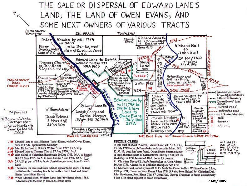
Road Return, dated 19 December 1766, "Road from St. James Church
to Thomas Rees' Mill, Philadelphia City Archives, Packet 29:186,
1766.
SAMUEL LANE'S SECTION
Deed of William Adams to Jacob Schrack, dated 2 March 1737/1738, 219 acres, 110 perches.
(Phila. Co. Deed Book I-10:357, Rec. 27 Apr 1772.)
Will of Matthias Koplin, 18 May 1769: "To grandson, Matthias Koplin, eldest son of my son, Christian, deceased".
(Phila. Co. Will File #73-1774, Prob. 21 Dec 1774.)
Will of Peter Rambo, 24 Aug 1744: Son John's land on east side of Perkiomen Creek contains about 120 acres; son Peter's land on west side of Perkiomen Creek contains about 80 acres.
(Phila. Co. Will File #23-1753, Prob. 16 Jan 1753.)
Deed of Thomas Church to John Read [Reed], dated 5 Sep 1775, 110 acres, 60 perches.
(Phila. Deed Book I-15:292.)
Deed of Rebecca Lane Executors [Samuel Lane's Estate] to Joseph Henry and Daniel Morgan, dated 5 April 1810, 205 Ľ acres.
(Mont. Co. Deed Book 26:256, Rec. 2 May 1810.)
Deed of Samuel Lane Executors to Andrew Todd, dated 30 Sep 1789. This was the land that Samuel Lane had set aside for the use of his sister, Eleanor Robeson and after her decease, sold to John Reed on 28 August 1778. Reed mortgaged 77 acres, 92 perches of the land on 29 August 1778 to the Executors which was to be paid by 1 August 1785. Action was brought by the executors against John Reed for the 200 pounds plus interest not paid; a judgment was obtained. September 30, 1789, the surviving Executors, in return for the payment of Reed's debt by Andrew Todd, turn over the 77 acres to Todd for him to take care of as he wishes.
(Mont. Co. Mortgage Book 1:334.)
Tavern Tract
Deed of John Richardson to Detrick Welker, dated 3 June 1777, 25 acres, 50 perches which was part of the original 201 acre tavern tract.
(Phila. Co. Deed Book D-1:124, Rec. 19 June 1777.)
Deed of Jacob Kline to Jonathan Meredith of Philadelphia, tanner, dated 12 April 1777, this deed states that John Richardson sold a plantation of 175 Ľ acres to Jacob Kline 4 June 1774. The sale of Kline to Meredith was subject to the following reservation: Detrick Welker and future owners of adjacent plot [which Richardson sold to Detrick Welker in Deed Book D-1:124] have the privilege of getting water for drink and house use from the spring in the orchard.
(Phila. Co. Deed Book D-1:124, Rec. 19 June 1777.)
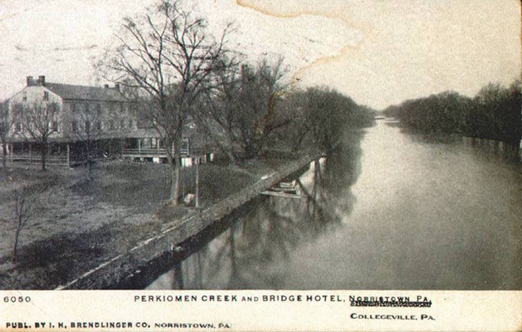
Perkiomen Bridge Hotel - Post Card circa 1906
Jonathan Meredith of Philadelphia, advertised this tavern for rent in 1785 and for sale in 1792 and finally sold it 13 May 1796 to William Fitzgerald.
(Mont. Co. Deed Book 8:456.)
Deed of Edward Lane to Thomas Church, dated 17 Aug 1770, 1 ľ acres. This is for 1 ľ acres on the east side of Perkiomen Creek opposite Perkiomen Bridge [Collegeville]. A deed for this land in 1818 states it is supposed to contain 1 ˝ acres, "warfs, landings, woods, ways, waters, rent issues".
(Phila. Co. Deed Book I-8:236, Rec. 7 Jan 1771; Mont. Co. Deed Book 61:228.)
Deed of Edward Lane to Detrick Welcker, dated 31 May 1777, 149 acres, 140 perches. One of the boundaries for this deed is "HusselTown" [an early name for Evansburg]. Two weeks later, Welker sold 31 acres, 90 perches to Rev. William Currie.
(Phila. Co. Deed Book D-1:167, Rec. 14 July 1777.)
Deed of Rev. William Curry, Dr. of Divinity, of Tredyffrin Township, Chester County, to William Lane, dated 7 Jun 1784, 31 acres, 90 perches. This deed states that 13 June 1777, Detrick Welker sold to Rev. William Curry, 31 acres, 90 perches of land – part of the 149 acres that Edward Lane had sold to Detrick Welker two weeks previous.
(Mont. Co. Deed Book 1:24.)
Deed of Edward and Ann Lane to John Gabel, dated 2 Nov 1763, 96 acres.
(Phila. Co. Deed Book I-5:210, Rec.16 Dec 1768.)
Deed of Edward and Ann Lane to William Couch, dated 1 Jan 1785, 80 acres, "For the love and affection which they bear to their said son-in-law".
(Mont. Co. Deed Book 1:62, rec. 17 Jan 1785.)
Deed of Edward and Ann Lane to son William Lane, dated 8 Oct 1783, "For love and affection which they beareth to their said son, William", 63 acres, 143 perches. This is the same land Edward and Ann Lane sold 25 Sep 1788 to James and Joshua Bean. It appears William Lane left Providence about 1788 and the land was then resold by his parents. William appears on the tax records for 1785; 1786, farmer 80 A, 2h, 2c, 1 Negroman; 1787, 93 acres, 2h, 4c 1 Negro; 1788, storekeeper, 50 acres, 1 Negro, 3h, 3c, "The above 90 Acres is a willful mistake there is 119 by Lane's Confession???"
(Mont. Co. Deed Book 1:453, Rec. 8 Oct 1785.)
Deed of Edward and Ann Lane to James and Joshua Bean, dated 25 Sep 1788, 63 acres, 143 perches. This is the 63 acres, 143 perches Edward had previously deeded to his son, William. This deed is quite faded at the end and barely legible.
(Mont. Co. Deed Book 4:365, Rec. 6 Aug 1789.)
Will of Edward Lane, 1 Mar 1798, To son William Lane the plantation I [Edward] now live on. 10 acres to daughter Eleanor Evans [married to Owen Evans] laid out some time ago.
(Mont. Co. Will File RW3843: Prob. 31 Aug 1799.)
(Mont. Co. Deed Book 19:243.)
Deed of William L. Evans to Edward Evans, dated 22 Feb 1841, Edward Lane had lot of 10 acres, to daughter Eleanor Evans. Eleanor Evans made will 1 June 1836 - 10 acres to son William L. Evans. Now William L. Evans sells to Edward Evans.
(Mont. Co. Deed Book 61:214, Rec. 2 Nov 1842.)
Puzzle
A plot of "about 65 acres" of land which had belonged to William Lane and was inherited by his son, Edward Lane. Edward Lane sold about 51 acres of this land to Jacob Pennebaker [married to Margaret Tyson] 23 July 1749 referenced in Montgomery County Deed Book 12:57. No deed for the actual sale has been found. Apparently, Edward Lane sold other parts of this "about 65 acre" plot but no deeds have yet been found or reference to sales.
The following deeds were used to place some of the land which Jacob Pennybaker purchased from Edward Lane and the land Owen Evans owned by 1798.
Puzzle #1: Deed of Jacob Casselberry Executors to William Casselberry, dated 2 June 1803, included one tract of land which Christian Recup sold to Jacob Casselberry 2 October 1782, 15 acres, 52 perches, adjoining land formerly of William Lane, land formerly of Richard Adams, and by John Fry.
(Mont. Co. Deed Book 17:73, Rec. 10 Aug 1803.)
Puzzle #2: Deed of Jacob Umstat of Skippack & Perkiomen, executor of the will of Alice Adams [widow of Richard Adams] to Christian Recup, dated 29 Sep 1774, states that Edward Lane sold 51 acres, 23 perches to Jacob Pennebaker 23 July 1749. No deed has been found for this sale. Jacob Pennebaker sold four acres, six perches to Alice Adams 16 April 1751. Now Jacob Umstat sells her landed property (consisting of 4 acres bounded by John Lloyds, by the Church land, by the Manatawney Road and by Edward Lane) to Christian Recup, of Upper Merion, cordwainer, which property had been described by Alice Adams as "my house and lott of land thereunto belonging containing four acres which I purchased of Jacob Pennebaker."
(Mont. Co. Deed Book 12:57; Phila. Co. Will Book O:454, 1769 will of Alse Addams.)
Puzzle #3: Deed of Edward Lane to John Gabell, 2 Nov 1763, names Michael Bard as owner of Puzzle #3 section of land.
(Phila. Co. Deed Book I-5:210, Rec 16 Dec 1768.)
Deed of Rev. William Currie of Tredyffrin Township, Chester County, Dr. of Divinity to Owen Evans, dated 7 June 1784: Two lots of land Nicholas Custer sold 19 July 1776 to Currie. One lot of 9 acres, 134 perches [Puzzle #4] adjoins John Layman [Puzzle #3].
(Mont. Co. Deed Book 1:23, Rec. 13 June 1784.)
Puzzle #4: Deed of Rev. William Currie of Tredyffrin Township, Chester County, Dr. of Divinity to Owen Evans, dated 7 June 1784: Two lots of land Nicholas Custer sold 19 July 1776 to Currie. One lot of 9 acres, 134 perches, adjoins John Layman [Puzzle #3], John Hall [Puzzle #7], and Peter Baker [Puzzle #5].
(Mont. Co. Deed Book 1:23, Rec. 13 June 1784.)
Nicholas Custer advertised the sale of about 22 acres on 13 March 1776:
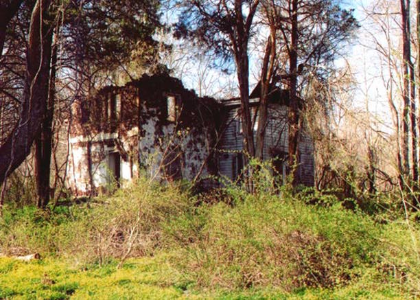
Abandoned House in Lower Providence Twp
Puzzle #5: Deed of Rev. William Currie of Tredyffrin Township, Chester County, Dr. of Divinity to Owen Evans, dated 7 June 1784: Two lots of land Nicholas Custer sold 19 July 1776 to Currie. One lot of 12 acres, 3 perches, adjoins John Newhouse [Puzzle #6], John Hall [Puzzle #7], and Nicholas Custer [Puzzle #4].
(Mont. Co. Deed Book 1:23, Rec. 13 June 1784.)
Puzzle #3, 4 & 5 combined:
Deed of Edward Evans to William L. Evans, dated 21 December 1818, two tracts of land. Tract #1: Owen Evans died intestate with three lots of land. Lot #1, 27 acres, 113 perches to Edward Evans, eldest son, containing one house, one barn, and one factory. [Puzzle #3, #4 & #5 – minus the land Owen Evans sold to Joseph Henry, 1 April 1800, 2 acres, 30 perches (DB 14:178) and to John Young 3 April 1805, 2 acres 31 perches (DB 20:162) - both lots being part of Puzzle #5.] Tract #2: William Pennick to Edward Evans 1 April 1815, 2 and 2/4 acres, 35 perches [Part of Puzzle #6 of which Rev. Slator Clay is owner of the balance of Puzzle #6; apparently both lots in #6 formerly the land of John Newhouse].
(Mont. Co. Deed Book 699:448, Rec. 28 Jul 1913.)
Deed of William L. Evans to Edward Evans, dated 24 July 1847, two tracts of land. Tract #1: Edward Evans sold to William L. Evans 1 December 1818, totaling 30 acres, 68 perches. Tract #2: Christian Mattis to William L. Evans, 8 July 1829, 2 acres, 115 perches [apparently the land Owen Evans sold to Joseph Henry, it being part of the land sold to Owen Evans by William Currie.] Selling part of Tract #1 and part of Tract #2; resurvey totals 32 acres, 3 perches. The lot appears to include all of Puzzle #3, all of Puzzle #4, part of Puzzle #5, and adjoins Puzzle #7. One of the boundaries is a public road connecting Germantown Pike and Ridge Pike, which road goes by William Casselberry's land [Puzzle #7].
(Mont. Co. Deed Book 76:647, Rec. 24 Apr 1850.)
Puzzle #6: See #5 and #3, 4 & 5 combined. The name Christian Dull as an early owner of this property comes from several deeds when lots in the Glebe Land were sold.
Puzzle #7: Deed of Jacob Casselberry Executors to William Casselberry, dated 2 June 1803. Included one tract of land which George Kressman and Sophia sold to Jacob Casselberry 1 June 1768, 10 acres, 71 perches, adjoining Peter Tyson, Church land, Jacob Pennebaker, and Edward Lane.
(Mont. Co. Deed Book 17:73, Rec. 10 Aug 1803.)
Deed of Rev. William Currie of Tredyffrin Township, Chester County, Dr. of Divinity to Owen Evans, dated 7 June 1784: Two lots of land Nicholas Custer sold 19 July 1776 to Currie. One lot of 9 acres, 134 perches, adjoins John Layman, John Hall [Puzzle #7], and Peter Baker.
(Mont. Co. Deed Book 1:23, Rec. 13 June 1784.)
Deed Book 76:647 [see Puzzle #3, #4, & #5 combined] has a public road connecting Germantown Pike and Ridge Pike, which road goes between William Casselberry's land and William L. Evans land.
Deed of Rev. William Currie of Tredyffrin Township, Chester County, Dr. of Divinity to Owen Evans, dated 7 June 1784: Two lots of land Nicholas Custer sold 19 July 1776 to Currie. One lot of 9 acres, 134 perches, adjoins John Layman, John Hall [Puzzle #7], and Peter Baker.
(Mont. Co. Deed Book 1:23.)
RICHARD BULL'S LAND
Deed of Richard Bull to Jno. Bull, dated 29 May 1760: This was for three tracts of land, 122 acres, 80 acres, and 19 acres 50 perches.
(Phila. Co. Deed Book H-14:488, Rec. 13 Feb 1762.)
JACOB UMSTATT'S LAND
Deed of Jacob Umstat and Michael Corbitt (Executors of Richard Umstat) to John McCrea and Miles Abbott, dated 14 April 1817. This deed references two tracts of land which Jacob and Ann Umstat sold to Richard Umstat [Umstead]: 140 acres with grist mill on 20 December 1773 and 28 and _ acres on 13 January 1780. The land has been resurveyed and contains 172 acres, 90 perches. The deeds for the sale of the two tracts of land from Jacob Umstat to Richard Umstead were not recorded.
(Mont. Co. Deed Book 34:107.)
Mortgage of John Umstat and Hugh Roberts, dated 27 July 1768. This was for two tracts of land. Tract 1: 62 plus acres, formerly the land of Jacob Gyslers/Geislers/Goislers, sold to John Umstat by Samuel and Sarah Boll [Bell] 5 June 1766. Tract 2: 100 acres "being the same tract which John [Jacob] Umstat and Ann the father and mother of the sd. John Umstat did grant unto the sd. John Umstat . . .28 November 1766". The deeds for these two tracts of land were not recorded.
(Phila. Co. Mortgage Book X-13:69, satisfied 7 Dec 1771.)
Deed of Jonathan Meredith of Philadelphia to Samuel Roberts Jr., dated 5 Feb 1788, 29 acres 24 perches. This deed states that Rudolph Bunner sold this tract to Jonathan Meredith 1 Dec 1778 and that it was part of 85 acres conveyed by Edward Lane to Jacob Umsted.
(Mont. Co. Deed Book 5:250.)
Deed of Mary Roberts, et al. to Amos Pennypacker, dated 18 June 1820. This deed states that Jacob Umstatt and Ann, his wife, sold 50 acres to Samuel Roberts, 2 May 1747.
(Mont. Co. Deed Book 43:477, Rec. 17 Mar 1828.)
ELIJAH DAVIS' LAND
Deed Poll of William Parr Esq., High Sheriff to Elijah Davis, dated 2 June 1767. Two tracts, 57 acres (land formerly of Jacob Gisler) and 10 acres.
(Phila. Co. Sheriff Book A:85.)
The metes and bounds for this deed do not plot correctly but the next deed selling this property [Mont. Co. Deed Book 9:308] does work. This land was advertised by William Parr, Sheriff, in The Pennsylvania Gazette.
Deed of Elijah Davis Executors to Thomas Davis, dated 12 Aug 1785, 137 acres, 100 perches: This deed states that Elijah Davis purchased this tract from Peter Bunnand and Hannah 2 May 1757.
(Mont. Co. Deed Book 16:184, Rec. 27 Nov 1802.)
Elijah Davis attempted to sell this land in 1771 when he advertised in the The Pennsylvania Gazette. At this time the land had a NEW saw mill.
RICHARD ADAMS' LAND
Deed of Richard Adams Executors to Harmon Umstat, dated 6 Dec 1748: 49 acres of land in Providence Twp.: This land was adj. to 150 acres of land owned by Harmon in Skippack Perkiomen [formerly land of his father Johannes Umstadt].
(Phila. Co. Deed Book I-8:179.)
SAMUEL LANE'S SECTION
Deed of William Adams to Jacob Schrack, dated 2 March 1737/1738, 219 acres, 110 perches.
(Phila. Co. Deed Book I-10:357, Rec. 27 Apr 1772.)
Will of Matthias Koplin, 18 May 1769: "To grandson, Matthias Koplin, eldest son of my son, Christian, deceased".
(Phila. Co. Will File #73-1774, Prob. 21 Dec 1774.)
Will of Peter Rambo, 24 Aug 1744: Son John's land on east side of Perkiomen Creek contains about 120 acres; son Peter's land on west side of Perkiomen Creek contains about 80 acres.
(Phila. Co. Will File #23-1753, Prob. 16 Jan 1753.)
Deed of Thomas Church to John Read [Reed], dated 5 Sep 1775, 110 acres, 60 perches.
(Phila. Deed Book I-15:292.)
Deed of Rebecca Lane Executors [Samuel Lane's Estate] to Joseph Henry and Daniel Morgan, dated 5 April 1810, 205 Ľ acres.
(Mont. Co. Deed Book 26:256, Rec. 2 May 1810.)
Deed of Samuel Lane Executors to Andrew Todd, dated 30 Sep 1789. This was the land that Samuel Lane had set aside for the use of his sister, Eleanor Robeson and after her decease, sold to John Reed on 28 August 1778. Reed mortgaged 77 acres, 92 perches of the land on 29 August 1778 to the Executors which was to be paid by 1 August 1785. Action was brought by the executors against John Reed for the 200 pounds plus interest not paid; a judgment was obtained. September 30, 1789, the surviving Executors, in return for the payment of Reed's debt by Andrew Todd, turn over the 77 acres to Todd for him to take care of as he wishes.
(Mont. Co. Mortgage Book 1:334.)
Tavern Tract
Deed of John Richardson to Detrick Welker, dated 3 June 1777, 25 acres, 50 perches which was part of the original 201 acre tavern tract.
(Phila. Co. Deed Book D-1:124, Rec. 19 June 1777.)
Deed of Jacob Kline to Jonathan Meredith of Philadelphia, tanner, dated 12 April 1777, this deed states that John Richardson sold a plantation of 175 Ľ acres to Jacob Kline 4 June 1774. The sale of Kline to Meredith was subject to the following reservation: Detrick Welker and future owners of adjacent plot [which Richardson sold to Detrick Welker in Deed Book D-1:124] have the privilege of getting water for drink and house use from the spring in the orchard.
(Phila. Co. Deed Book D-1:124, Rec. 19 June 1777.)
Perkiomen Bridge Hotel - Post Card circa 1906
Jonathan Meredith of Philadelphia, advertised this tavern for rent in 1785 and for sale in 1792 and finally sold it 13 May 1796 to William Fitzgerald.
(Mont. Co. Deed Book 8:456.)
- 9
March 1785, The Pennsylvania Gazette:
TO BE LETT,
THAT well accustomed TAVERN and FARM, situate at Perkioming Ferry, in
Providence township, Montgomery county, now occupied by Frederick Houseman, about
25 miles from Philadelphia, on the Reading road; it is one of the best stands for a tavern
between Philadelphia and Reading, and the house and buildings very commodious for
that purpose. Possession may be had the first of April next. For terms, apply to the
subscriber, in Third street, Philadelphia.
March 9, 1785. JONATHAN MEREDITH
(Item #713116: The Pennsylvania Gazette, online by subscription at Accessible Archives)
January 4, 1792, The Pennsylvania Gazette
TO BE SOLD,
And possession given the first day of April next, A VERY valuable Plantation and well accustomed Tavern, being the ferry-house on Perkioming creek, about twenty-five miles from Philadelphia, on the great road to Reading. There are on the premises an excellent stone dwelling house, with other buildings, a very large stone barn, stone sheds for horses, &c. a never-failing spring of water near the door. The plantation consists of about one hundred and seventy-five acres of land, about twenty-five or thirty whereof are meadow, a large proportion of good thriving timber, the rest plowland. The situation would suit a tavern, store or tan-yard.
For terms apply to JONATHAN MEREDITH, in Philadelphia, who will give an indisputable title for the same, and make the payments perfectly easy to the purchaser.
January 2d, 1792.
(Item #78037: The Pennsylvania Gazette, online by subscription at Accessible Archives)
Deed of Edward Lane to Thomas Church, dated 17 Aug 1770, 1 ľ acres. This is for 1 ľ acres on the east side of Perkiomen Creek opposite Perkiomen Bridge [Collegeville]. A deed for this land in 1818 states it is supposed to contain 1 ˝ acres, "warfs, landings, woods, ways, waters, rent issues".
(Phila. Co. Deed Book I-8:236, Rec. 7 Jan 1771; Mont. Co. Deed Book 61:228.)
Deed of Edward Lane to Detrick Welcker, dated 31 May 1777, 149 acres, 140 perches. One of the boundaries for this deed is "HusselTown" [an early name for Evansburg]. Two weeks later, Welker sold 31 acres, 90 perches to Rev. William Currie.
(Phila. Co. Deed Book D-1:167, Rec. 14 July 1777.)
Deed of Rev. William Curry, Dr. of Divinity, of Tredyffrin Township, Chester County, to William Lane, dated 7 Jun 1784, 31 acres, 90 perches. This deed states that 13 June 1777, Detrick Welker sold to Rev. William Curry, 31 acres, 90 perches of land – part of the 149 acres that Edward Lane had sold to Detrick Welker two weeks previous.
(Mont. Co. Deed Book 1:24.)
Deed of Edward and Ann Lane to John Gabel, dated 2 Nov 1763, 96 acres.
(Phila. Co. Deed Book I-5:210, Rec.16 Dec 1768.)
Deed of Edward and Ann Lane to William Couch, dated 1 Jan 1785, 80 acres, "For the love and affection which they bear to their said son-in-law".
(Mont. Co. Deed Book 1:62, rec. 17 Jan 1785.)
Deed of Edward and Ann Lane to son William Lane, dated 8 Oct 1783, "For love and affection which they beareth to their said son, William", 63 acres, 143 perches. This is the same land Edward and Ann Lane sold 25 Sep 1788 to James and Joshua Bean. It appears William Lane left Providence about 1788 and the land was then resold by his parents. William appears on the tax records for 1785; 1786, farmer 80 A, 2h, 2c, 1 Negroman; 1787, 93 acres, 2h, 4c 1 Negro; 1788, storekeeper, 50 acres, 1 Negro, 3h, 3c, "The above 90 Acres is a willful mistake there is 119 by Lane's Confession???"
(Mont. Co. Deed Book 1:453, Rec. 8 Oct 1785.)
Deed of Edward and Ann Lane to James and Joshua Bean, dated 25 Sep 1788, 63 acres, 143 perches. This is the 63 acres, 143 perches Edward had previously deeded to his son, William. This deed is quite faded at the end and barely legible.
(Mont. Co. Deed Book 4:365, Rec. 6 Aug 1789.)
- NOTE:
Neither of the above two deeds have metes and bounds that work. It is
only by comparing these two deeds and adjacent landowner deeds, that
somewhat of a plot of the land can be made. The land did include a "neck"
that is above Germantown Pike because the adjacent landowners in Deed
Book 4:365 are Henry Detweiler, William Rittenhouse, and William Lane.
Montgomery County Deed Book 29:243, William Lane to Owen Evans, was used
to help with the metes and bounds on the west side of the property. The
landowner on the east was Owen Evans and this appears to be the land
William Lane gave to daughter Eleanor, wife of Owen Evans.
(Montgomery County Deed Book 61:214).
Will of Edward Lane, 1 Mar 1798, To son William Lane the plantation I [Edward] now live on. 10 acres to daughter Eleanor Evans [married to Owen Evans] laid out some time ago.
(Mont. Co. Will File RW3843: Prob. 31 Aug 1799.)
-
NOTE:
In 1793, Edward Lane was taxed on 180 acres, "old man". 1798 Direct
House Tax: Edward Lane, 179 acres with barn, occupied by Edward
Couch, and 1 acre with house, also occupied by Edward Couch; total 180
acres. Two-story stone house, 30 x 20, 10 windows, 12 lights, 1 outhouse
on 1 acre with a 1-story, stone, 15
x 18 kitchen; a 40 x 30 stone and log barn with 179 acres.
(Mont. Co. Deed Book 19:243.)
Deed of William L. Evans to Edward Evans, dated 22 Feb 1841, Edward Lane had lot of 10 acres, to daughter Eleanor Evans. Eleanor Evans made will 1 June 1836 - 10 acres to son William L. Evans. Now William L. Evans sells to Edward Evans.
(Mont. Co. Deed Book 61:214, Rec. 2 Nov 1842.)
-
NOTE:
1798 Direct House Tax: Owen Evans had 39 acres with barn plus one
acre with house; total 40 acres. 40 x 20 2-story stone house, 12 windows,
15 lights, 1 outhouse, 1-story 12 x 15 stone kitchen on 1 acre; 35 x 20
stone and frame barn with 39 acres. This appears to include the ten acres
given to his wife by her father.
Puzzle
A plot of "about 65 acres" of land which had belonged to William Lane and was inherited by his son, Edward Lane. Edward Lane sold about 51 acres of this land to Jacob Pennebaker [married to Margaret Tyson] 23 July 1749 referenced in Montgomery County Deed Book 12:57. No deed for the actual sale has been found. Apparently, Edward Lane sold other parts of this "about 65 acre" plot but no deeds have yet been found or reference to sales.
The following deeds were used to place some of the land which Jacob Pennybaker purchased from Edward Lane and the land Owen Evans owned by 1798.
Puzzle #1: Deed of Jacob Casselberry Executors to William Casselberry, dated 2 June 1803, included one tract of land which Christian Recup sold to Jacob Casselberry 2 October 1782, 15 acres, 52 perches, adjoining land formerly of William Lane, land formerly of Richard Adams, and by John Fry.
(Mont. Co. Deed Book 17:73, Rec. 10 Aug 1803.)
Puzzle #2: Deed of Jacob Umstat of Skippack & Perkiomen, executor of the will of Alice Adams [widow of Richard Adams] to Christian Recup, dated 29 Sep 1774, states that Edward Lane sold 51 acres, 23 perches to Jacob Pennebaker 23 July 1749. No deed has been found for this sale. Jacob Pennebaker sold four acres, six perches to Alice Adams 16 April 1751. Now Jacob Umstat sells her landed property (consisting of 4 acres bounded by John Lloyds, by the Church land, by the Manatawney Road and by Edward Lane) to Christian Recup, of Upper Merion, cordwainer, which property had been described by Alice Adams as "my house and lott of land thereunto belonging containing four acres which I purchased of Jacob Pennebaker."
(Mont. Co. Deed Book 12:57; Phila. Co. Will Book O:454, 1769 will of Alse Addams.)
Puzzle #3: Deed of Edward Lane to John Gabell, 2 Nov 1763, names Michael Bard as owner of Puzzle #3 section of land.
(Phila. Co. Deed Book I-5:210, Rec 16 Dec 1768.)
Deed of Rev. William Currie of Tredyffrin Township, Chester County, Dr. of Divinity to Owen Evans, dated 7 June 1784: Two lots of land Nicholas Custer sold 19 July 1776 to Currie. One lot of 9 acres, 134 perches [Puzzle #4] adjoins John Layman [Puzzle #3].
(Mont. Co. Deed Book 1:23, Rec. 13 June 1784.)
Puzzle #4: Deed of Rev. William Currie of Tredyffrin Township, Chester County, Dr. of Divinity to Owen Evans, dated 7 June 1784: Two lots of land Nicholas Custer sold 19 July 1776 to Currie. One lot of 9 acres, 134 perches, adjoins John Layman [Puzzle #3], John Hall [Puzzle #7], and Peter Baker [Puzzle #5].
(Mont. Co. Deed Book 1:23, Rec. 13 June 1784.)
Nicholas Custer advertised the sale of about 22 acres on 13 March 1776:
- TO BE SOLD, A VALUABLE LOT or PLANTATION, situate in Providence
township, Philadelphia county, joining the great road that leads from
Philadelphia to Reading, between Perkiomen and Skippack, near the English
Church, containing about 22 acres of good LAND,
with a good stone dwelling house, a well at the door, and a good
bearing orchard, containing
about 80 or 90 apple trees. Whoever inclines to purchase the said
plantation, or lot of land,
may apply to the subscriber, living on the premises, and know the
terms of sale.
-
March 13, 1776, The
Pennsylvania Gazette
-
NICHOLAS CUSTER.
(Item #59059, The Pennsylvania Gazette, online by subscription at Accessible Archives)
Abandoned House in Lower Providence Twp
Puzzle #5: Deed of Rev. William Currie of Tredyffrin Township, Chester County, Dr. of Divinity to Owen Evans, dated 7 June 1784: Two lots of land Nicholas Custer sold 19 July 1776 to Currie. One lot of 12 acres, 3 perches, adjoins John Newhouse [Puzzle #6], John Hall [Puzzle #7], and Nicholas Custer [Puzzle #4].
(Mont. Co. Deed Book 1:23, Rec. 13 June 1784.)
Puzzle #3, 4 & 5 combined:
Deed of Edward Evans to William L. Evans, dated 21 December 1818, two tracts of land. Tract #1: Owen Evans died intestate with three lots of land. Lot #1, 27 acres, 113 perches to Edward Evans, eldest son, containing one house, one barn, and one factory. [Puzzle #3, #4 & #5 – minus the land Owen Evans sold to Joseph Henry, 1 April 1800, 2 acres, 30 perches (DB 14:178) and to John Young 3 April 1805, 2 acres 31 perches (DB 20:162) - both lots being part of Puzzle #5.] Tract #2: William Pennick to Edward Evans 1 April 1815, 2 and 2/4 acres, 35 perches [Part of Puzzle #6 of which Rev. Slator Clay is owner of the balance of Puzzle #6; apparently both lots in #6 formerly the land of John Newhouse].
(Mont. Co. Deed Book 699:448, Rec. 28 Jul 1913.)
Deed of William L. Evans to Edward Evans, dated 24 July 1847, two tracts of land. Tract #1: Edward Evans sold to William L. Evans 1 December 1818, totaling 30 acres, 68 perches. Tract #2: Christian Mattis to William L. Evans, 8 July 1829, 2 acres, 115 perches [apparently the land Owen Evans sold to Joseph Henry, it being part of the land sold to Owen Evans by William Currie.] Selling part of Tract #1 and part of Tract #2; resurvey totals 32 acres, 3 perches. The lot appears to include all of Puzzle #3, all of Puzzle #4, part of Puzzle #5, and adjoins Puzzle #7. One of the boundaries is a public road connecting Germantown Pike and Ridge Pike, which road goes by William Casselberry's land [Puzzle #7].
(Mont. Co. Deed Book 76:647, Rec. 24 Apr 1850.)
Puzzle #6: See #5 and #3, 4 & 5 combined. The name Christian Dull as an early owner of this property comes from several deeds when lots in the Glebe Land were sold.
Puzzle #7: Deed of Jacob Casselberry Executors to William Casselberry, dated 2 June 1803. Included one tract of land which George Kressman and Sophia sold to Jacob Casselberry 1 June 1768, 10 acres, 71 perches, adjoining Peter Tyson, Church land, Jacob Pennebaker, and Edward Lane.
(Mont. Co. Deed Book 17:73, Rec. 10 Aug 1803.)
Deed of Rev. William Currie of Tredyffrin Township, Chester County, Dr. of Divinity to Owen Evans, dated 7 June 1784: Two lots of land Nicholas Custer sold 19 July 1776 to Currie. One lot of 9 acres, 134 perches, adjoins John Layman, John Hall [Puzzle #7], and Peter Baker.
(Mont. Co. Deed Book 1:23, Rec. 13 June 1784.)
Deed Book 76:647 [see Puzzle #3, #4, & #5 combined] has a public road connecting Germantown Pike and Ridge Pike, which road goes between William Casselberry's land and William L. Evans land.
Deed of Rev. William Currie of Tredyffrin Township, Chester County, Dr. of Divinity to Owen Evans, dated 7 June 1784: Two lots of land Nicholas Custer sold 19 July 1776 to Currie. One lot of 9 acres, 134 perches, adjoins John Layman, John Hall [Puzzle #7], and Peter Baker.
(Mont. Co. Deed Book 1:23.)
RICHARD BULL'S LAND
Deed of Richard Bull to Jno. Bull, dated 29 May 1760: This was for three tracts of land, 122 acres, 80 acres, and 19 acres 50 perches.
(Phila. Co. Deed Book H-14:488, Rec. 13 Feb 1762.)
JACOB UMSTATT'S LAND
Deed of Jacob Umstat and Michael Corbitt (Executors of Richard Umstat) to John McCrea and Miles Abbott, dated 14 April 1817. This deed references two tracts of land which Jacob and Ann Umstat sold to Richard Umstat [Umstead]: 140 acres with grist mill on 20 December 1773 and 28 and _ acres on 13 January 1780. The land has been resurveyed and contains 172 acres, 90 perches. The deeds for the sale of the two tracts of land from Jacob Umstat to Richard Umstead were not recorded.
(Mont. Co. Deed Book 34:107.)
Mortgage of John Umstat and Hugh Roberts, dated 27 July 1768. This was for two tracts of land. Tract 1: 62 plus acres, formerly the land of Jacob Gyslers/Geislers/Goislers, sold to John Umstat by Samuel and Sarah Boll [Bell] 5 June 1766. Tract 2: 100 acres "being the same tract which John [Jacob] Umstat and Ann the father and mother of the sd. John Umstat did grant unto the sd. John Umstat . . .28 November 1766". The deeds for these two tracts of land were not recorded.
(Phila. Co. Mortgage Book X-13:69, satisfied 7 Dec 1771.)
Deed of Jonathan Meredith of Philadelphia to Samuel Roberts Jr., dated 5 Feb 1788, 29 acres 24 perches. This deed states that Rudolph Bunner sold this tract to Jonathan Meredith 1 Dec 1778 and that it was part of 85 acres conveyed by Edward Lane to Jacob Umsted.
(Mont. Co. Deed Book 5:250.)
Deed of Mary Roberts, et al. to Amos Pennypacker, dated 18 June 1820. This deed states that Jacob Umstatt and Ann, his wife, sold 50 acres to Samuel Roberts, 2 May 1747.
(Mont. Co. Deed Book 43:477, Rec. 17 Mar 1828.)
ELIJAH DAVIS' LAND
Deed Poll of William Parr Esq., High Sheriff to Elijah Davis, dated 2 June 1767. Two tracts, 57 acres (land formerly of Jacob Gisler) and 10 acres.
(Phila. Co. Sheriff Book A:85.)
The metes and bounds for this deed do not plot correctly but the next deed selling this property [Mont. Co. Deed Book 9:308] does work. This land was advertised by William Parr, Sheriff, in The Pennsylvania Gazette.
- March
26, 1767, The Pennsylvania Gazette
BY virtue of a writ of venditioni exponas to me directed, will be sold, by public vendue, on Thursday, the 16th day of April next, at the house of Edward Wells, at Skippack, at 3 in the afternoon, a certain messuage, plantation, and tract of land, situate in the township of New Providence, in the county of Philadelphia, containing 70 acres, and 110 perches of land,
bounded by lands of John Bull, Esq; John Umstead, and others; late the estate of Jacob Gisler, seized and taken in execution by WILLIAM PARR, Sheriff.
Deed of Elijah Davis Executors to Thomas Davis, dated 12 Aug 1785, 137 acres, 100 perches: This deed states that Elijah Davis purchased this tract from Peter Bunnand and Hannah 2 May 1757.
(Mont. Co. Deed Book 16:184, Rec. 27 Nov 1802.)
Elijah Davis attempted to sell this land in 1771 when he advertised in the The Pennsylvania Gazette. At this time the land had a NEW saw mill.
- March 7,
1771, The Pennsylvania Gazette
ON the 25th day of this instant March, at 2 o, by the subscriber, will be exposed to
sale, by public vendue, a certain messuage, or tract of land, adjoining Skippack creek, in the township of Providence, and county of Philadelphia, containing 140 acres of very good land, well timbered, with a good dwelling house, and two cellars under, very good barn and stables, 12 acres of good meadow, and as much more may be made, the upland being exceeding good for wheat and other grain, and also for pasture; there are also on said place, 3 bearing orchards of choice fruit, and a new sawmill, in good repair, and well situated for plenty of custom; the premises being a beautiful situation on the public road leading from Reading to Philadelphia, 23 miles from the city. There will also be sold, another tract of land, adjoining the above tract, and the public road aforesaid, containing 67 acres of good land, well timbered, with a good dwelling house and barn, 2 good bearing orchards, and 8 acres of very good meadow; it being a beautiful seat for a store, or other public business.
- ELIJAH DAVIS
RICHARD ADAMS' LAND
Deed of Richard Adams Executors to Harmon Umstat, dated 6 Dec 1748: 49 acres of land in Providence Twp.: This land was adj. to 150 acres of land owned by Harmon in Skippack Perkiomen [formerly land of his father Johannes Umstadt].
(Phila. Co. Deed Book I-8:179.)
Return to Lane Land Tract Maps