Stewart
Ranch
Historic
Pictures
All photographs donated by Gerry Perry of
Henderson, NV
(2007 Copyright) unless indicated otherwise
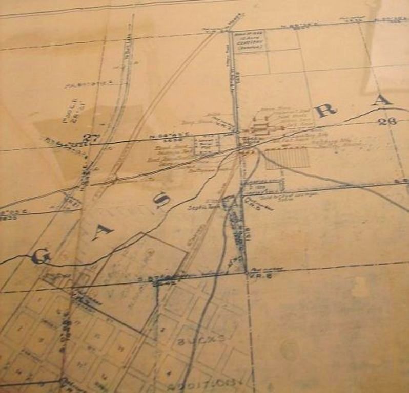 |
This map shows the Stewart Ranch during the early
part of the 1900s. Near the center top, is the 10 acres
designated as the ranch cemetery. This cemetery is
located at what appears to be the intersection of Owens
and Las Vegas Blvd. No., what is today the border between
Las Vegas and North Las Vegas To the left of the
"R" are the various buildings of the ranch.
This is near the intersection of what is today Washington
and Las
Vegas Blvd. No. At the bottom of the picture, on the
left, is the town of Las Vegas, as it existed at that
time.
(This map located at University
of Nevada library, Historic Collections who gave
permission to photograph this and the other pictures in
these pages -gp) |
For inquiries about Nevada
Cemeteries, burials and/or this project, or about this page or
the pictures,
contact Gerry Perry the Nevada
Tombstone Coordinator,
This page was last updated October 12,
2008
Copyright © 2008 USGenWeb Tombstone Project, Gerry Perry
| USGENWEB
NOTICE: In keeping with our policy of providing free
information on the internet, material may be freely used
by non-commercial entities, as long as this notice
remains on all copied files and permission is obtained by
the contributor of this file. |
| USGENWEB
ARCHIVES NOTICE: These electronic pages may NOT be
reproduced in any format for profit or presentation by
any other organization or persons. Persons or
organizations desiring to use this material, must obtain
the written consent of the contributor, or the legal
representative of the submitter, and contact the listed
USGenWeb archivist with proof of this consent. |