
Contributed for use in the USGenWeb Archives by Donna Bluemink.
USGENWEB NOTICE: Printing this file by non-commercial individuals and libraries is encouraged, as long as all notices and submitter information is included. Any other use, including copying files to other sites requires permission from the submitters PRIOR to uploading to any other sites. We encourage links to the state and county table of contents.
CHRISTOPHER GIST'S JOURNALS
WITH HISTORICAL, GEOGRAPHICAL AND ETHNOLOGICAL NOTES
AND BIOGRAPHIES OF HIS CONTEMPORARIES
BY
WILLIAM M. DARLINGTON [1815-1889]
PITTSBURGH, J. R. WELDIN & CO.,
1893.
[Part 4.]
[Pages 90-136. Page numbers will appear in the text in brackets in bold print.]
[Transcription is Verbatim.]
[Footnotes are in smaller font.]
[90] FIRST JOURNEY.
NOTES TO CHRISTOPHER GIST'S JOURNAL OF 1750-1.
October 31, 1750.— Colonel Cresap was an Agent and member of the Ohio company, see Biographical Sketch in the Appendix. "Old Town." So called for a town or village of the Shawanese Indians, who abandoned the upper Potomac region in the years 1727-9 and removed to the Ohio and Allegheny rivers. It is in Old Town, District of Allegheny county, Maryland, fifteen miles southeast of Cumberland, on the north side of the Potomac, and opposite to Green Spring Station, on the Baltimore and Ohio Railway.
November 3.—Gist's route from Old Town lay by the Warrior's Path, along the base of the Great Warrior Mountain, on the eastern side, passing through the present district of Flintstone, Allegheny county, Maryland, and the townships of Southhampton, Monroe and Providence, in Bedford county, Pennsylvania, reaching the Juniata at the Warrior's Gap, near the village of Bloody Run, eight miles east of the present town of Bedford, there he entered the old Indian path leading westward. From the Juniata, where Bedford now stands, two paths led to the Ohio (Allegheny), the upper directly north to Frankstown, thence northwest to Venango (now Franklin), the lower path led west to Shannopin's Town (now Pittsburgh), the latter was the route taken by Gist. (Hutchins' Map, 1778; Scull's ditto, 1770. "Traders' Table of Distances to the Ohio;" "Colonial Records of Pennsylvania," Vol. V, p. 750. "Account of the Road to Logstown," by John Harries, in 1754, "Pennsylvania Archives," Vol. II, p. 135.
[Map of Lake Erie Region. Map not named.]
[91] November 5-9.—In Shade Township, Somerset county, Stony Creek, a branch of the Conemaugh River; the path crossed it near the present Stoyestown, in Somerset county.
November 11.—The North and East Forks of the Quemahoning, a branch of Stony creek; (In the Delaware tongue "Ach sin-hanac" or "Stony Stream.") these streams here flowing northeastward, misled Gist into supposing they emptied into the Susquehannah; they are so erroneously laid down from his notes on Fry and Jefferson's map of 1751. Que-Mahoning from Curoa (pine trees,) and Mahonink (a stream,) on which there is a Salt lick. (Delaware.)
November 12.—The ridge of the Alleghenies known as Laurel Hill.
November 14.—This old Indian town stood on the wide and fertile bottom land on the north side of the Loyalhanna creek, a large branch of the Kiskiminitas River. The present town of Ligonier, in Westmoreland county, occupies the same spot, fifty-one miles east of Pittsburgh, marked "Loyal Hannin Old Town—fifty miles to Shannopin's Town," on a map presented to the Governor and council of Pennsylvania, by John Pattin (Indian Trader), and Andrew Montour (a Six Nation chief and Interpreter), March 2, 1754. ("Colonial Records," Vol. V, pp. 747, 750.) Laurel-hanne, signifying the middle stream in the Delaware tongue. (Heckwelder in "Transactions of the Moravian Historical Society for 1872," p. 28. McCullough, "Narrative and Incidents of Border Life," Lancaster, 1841, p. 81. See also "Trumbull on Indian Geographical Names," Vol. II, p. 12. "Collection of the Connecticut Historical Society.") The stream here is half way between the Juniata at Bedford and the Ohio at the Forks.
November 16.—The path here left the Loyalhanna and by a northwest course passed through the Chestnut Ridge, at [92] the Miller's Run Gap, and reached the creek again, at the Big Bottom, below the present town of Latrobe, on the Pennsylvania Central Railway; there the trail forked, one branch led northwest down the creek to the Kiskiminitas River, at Blacklegs Indian town, by the mouth of the creek of the same name; thence it continued down to the Kiskiminitas Old Town, at Old Town Run, about seven miles from the Allegheny River. The other branch, or main trail (travelled by Gist), led directly westward to Shannopin's Town, by a course parallel with and a few miles north of the Pennsylvania Railroad. The courses stated, by Gist for ,the 16th and 17th November are manifestly wrong; the distances are given much more correctly. (See Colonial Records," Vol. V. p. 750-1. "Pennsylvania Archives," Vol. II, p. 135. Scull's Map, 1770. Hutchins' 1778. Evans and Mitchell's, 1755.)
November 17.—This camp was Cockey's Cabin, its owner a Delaware Indian, well known by the traders. It was on Bushy Run, a branch of Turtle creek, near the place of the two days' battle between the army under Colonel Bouquet and the Indians, led by Guyasuta (Kiashuta), August 5th and 6th, 1763, about three miles north of Penn Station, on the Pennsylvania Railroad, and twenty-three miles east of Pittsburgh. (Pennsylvania Archives," Vol. II, p. 135. "Bouquet's Expedition, Philadelphia, 1765." "Virginia State Papers, 1875.") Shannopin's Town, on the bank of the Allegheny River, now in the city of Pittsburgh, between Penn Avenue, Thirtieth Street and the Two Mile Run, in the Twelfth Ward. It was small, containing about twenty wigwams, fifty or sixty natives and twenty warriors. ("Colonial Records," Vol. V, p. 702; id., Vol. VII, p. 561.) It was much frequented by the traders. By it ran the main Indian trail from the east to the west. In April, 1730, Governor Thomas, [93] at Philadelphia, received a message from "the chiefs of ye Delewares at Allegaeniny, on the main road," taken down (written) by Edmond Cartledge, and interpreted by James Le Tort, both noted traders. Among the names signed to the message is that of "Shannopin his X mark." The message of the chiefs was to explain the cause of the death of a white man named Hart, and the wounding of another, Robinson, down the Ohio occasioned by rum. The bringing of such great quantities of liquor into the woods they desired the Governor to prevent, as wall as to limit the number of traders. Shannopin's name appears signed to several documents in the State Archives. ("Pennsylvania Archives," Vol. I, p. 255; do., p. 341.) He made a speech to Conrad Weiser, at Logstown, September 15, 1748. ("Journal of Weiser," Historical Society of Pennsylvania Collection, Vol. I, p. 29; "Colonial Records," Vol. V, p. 355.) He was present at the conference held at Philadelphia August 1, 1740, between the Proprietary, Thomas Penn, Governor Thomas, the Provincial Council, and the Delaware and Mingoe Indians, from Ohio, Allegheny, Shamokin, etc. ("Colonial Records," Vol. IV, p. 441.) Shannopin died about the year 1749. ("Colonial Records," Vol. V, p. 519. See also "Journals of Assembly," 1754, pp. 295 and 299. "Colonial Records," Vol. V, pp. 746, 751, etc. London Magazine for June, 1754. Evans and Mitchell's Maps, 1755. Fry and Jefferson's Maps, 1751.)
November 21.—The width of the river here is about, the as stated in the journal, although the banks have been partly washed away by freshets.
November 24.—"At Shannopin's there is a fording place in very dry times and the lowest times down the river." ("Analysis of Map of the Middle Colonies," by Lewis Evans, 1775, p. 25.) In the first half of the last century the Allegheny River was generally [94] called the Ohio, of which it is the head branch."The Ohio" by the Senecas. Allegheny is the name of the same river in the Delaware language. Both words signify "the fine or fair river." Post was a Moravian missionary amongst the Ohio Indians for many years. (Christian F. Post in his Second Journal, 1758. London, 1759, p. 17, reprinted in Appendix to Proud's "History of Pennsylvania," 1798, Vol. II; also in Craig's "Olden Time," Vol. I.) He was twice married among them and thoroughly understood various Indian dialects. He was often employed on Indian affairs by the eolonial authorities. On the map prefixed to "Washington's Journal of 1753—4, London, 1754," reprinted by Joseph Sabin, New York, 1865, the Allegheny is marked "The Ohio or Allegheny River," and the main stream "The Ohio or the Fair River." (See also "Weiser's Journal, 1748." "Colonial Records," Vol. V, p. 349. "Collection Pennsylvania Historical Society," Vol. I, p. 23.) In the language of the different tribes of the Iroquois, or Six Nations, there are some variations of the word Ohio, none of its meaning. In the Seneca, Cayuga and Mohawk dialects it is O-heéyo; in the Onondago and Tuscarora O-heé-yee; in the Oneida, O-heé, the same as Allegheny—" fair or beautiful "—which the French rendered " La Belle Rivière." ("Morgan's League of the Iroquois, p. 394. "Collection of the Connecticut Historical Society, Vol. II, p. 13.") The early traders in Kentucky and on the Ohio called it Allegheny, or Ohio, as they happened to trade most with the Iroquois or Delawares. On the map of Cornelli, "North America with the New Discoveries of the Year 1688," published at Venice in 169o, the main part of the Ohio is laid down and inscribed "R Ohio or la Belle Rivière, said by the savages to have its source near the Lake Frontenac" (Ontario). In the "Procés Verbal" (Declaration of the taking possession of Louisiana, at the mouth of the Mississippi, by the Sieur de La Salle, April 9, [95] 1682, the names "Ohio" and "Alighin" are both evidently given to the same stream. (This document preserved in the French Archives at Paris, is printed in Sparks' Life of La Salle," Appendix, p. 194. "American Biographies, New Series, 1864, Vol. I, also in "Monette's Valley of the Mississippi," Vol. I, p. 144. "Historical Collection of Louisiana," by B. F. French, 1846, p. 49, Vol. I.) After crossing the river from Shannopins, Gist's route was by the old path which ran by the line occupied now by East and West Ohio Streets, in Allegheny City, to Beaver Avenue, thence along it and down the river bank to Sewickley, twelve miles below Pittsburgh.
[See Lewis Evans' Map, 1755-1775.]
November 25 —Logstown. This once noted Indian and French town stood on the first and second bank on the north side of the Ohio River, immediately below the present town of Economy, eighteen miles from Pittsburgh, in Beaver County, Pennsylvania; the well-known German settlement, of which George Rapp was the head, established there in 1824. Logstown Run, a small stream, and the bar in the river perpetuate the name and locality. The town was first described by Conrad Weiser in the Journal of his visit to it in August, 1748. ("Collection of the Pennsylvania Historical Society," Vol. I, p. 23, etc. "Colonial Records of Pennsylvania," Vol. V, p. 348, etc.) William Franklin (son of Benjamin), afterwards the Royal Governor of New Jersey, was one of Weiser's company. ("Pennsylvania Archives," Vol. II, pp. 10-15. Evans' "Analysis of Map of the Middle Colonies, 1755," p. 10.) The Shawanese established themselves here, probably soon after their migration from the Upper Potomac country and Eastern Pennsylvania, in 1727-30. In the summer of 1749 Captain Bienville de Celeron, in command of a detachment composed of eight subaltern officers, six cadets, an armorer, twenty soldiers, one hundred and [96] eighty Canadians, thirty Iroquois and twenty-five Abanakis, descended the Allegheny and Ohio rivers, from Canada, for the purpose of taking military possession of the country. (See "Fort Pitt.") Their route from Lake Erie to the Allegheny was by the old Portage to the head of Chautauqua Lake; thence down the lake to the outlet, through to the Chenango Creek, and by it to the Allegheny. In evidence of the French king's claim, leaden plates, with suitable inscriptions, were deposited at various points along the rivers. A number of them were found in after years. (See fac-simile of one in Craig's "Olden Time," Vol. II; of another in "New York Colonial History," Vol. VI, p. 611, also in Hildreth's "Pioneer History" and De Hass' "Indian Wars of Western Virginia," 1851. "Magazine of American History," March, 1878.) The French arrived at Logstown on the 9th or 10th of August, encamped and remained about two days.
Contrecoeur, to whom Ensign Ward surrendered the little fort at the Forks of the Ohio, April 17, 1754, where Pittsburgh now stands, and who named it Du Quesne, was one of Celeron's officers. Coulon de Valliers, to whom Washington capitulated at Fort Necessity, in June of the same year, was another. He was a brother of Jumonville, killed in a previous contest with Washington's troops. George Croghan arrived at Logstown just after the French departed. ("New York Colonial History," Vol. VI, p. 531; do., Vol. VII, p. 267.) He had a Trading House there, in which Weiser lodged during his visit the previous year. ("Weiser's Journal.") Washington and Gist remained here five days while on their way to Venango and Le Boeuf, in 1753. (Journals of Washington and Gist, 1754.) Washington was again here in 1770 on his way to the Kanawha. (Journals in Sparks' "Life of Washington," Vol. 2, Appendix; also in Craig's "Olden Time," Vol. I.) In June, 1752, a treaty was [97] made here between the Indians and the commissioners of Virginia, Fry, Lomax and Patton. Gist was present, George Croghan also. Arthur Lee, in his "Journal of 1784," mentions Logstown as "formerly a settlement on both sides of the Ohio." ("Life of Lee," Vol. II, p. 384.) A settlement on the south side of the river is called Indian Logstown in "Western Navigation," edition of 1814, p. 76. (See also Cumming's "Western Tour," Pittsburgh, 1816, p. 80.) George Croghan, in his Journal of 1765, describes Logstown as "an old Settlement of the Shawanese, situated on a high bank on the north side of the Ohio River, a fine fertile country around it." An error in printing "south" for "north" has occasioned some controversy. His description better applies to the north side, and is so written in the manuscript. (Craig's "Olden Time," Vol. I, p. 403. Butler's "History of Kentucky," second edition. Appendix, p. 459.) The tract on the south side appears to have been surveyed for Alexander M'Kee in 1769, ("Pennsylvania Archives," Vol. IV, p. 346.) and was advertised for public sale by the agents of the State "at Pittsburgh, on the 12th day of October next." Three hundred acres of land, on the south side of the Ohio, located by Alexander McKee, including his house and improvements opposite Logstown and confiscated as the property of the said Alexander McKee. (Pennsylvania Gazette, September 8, 1784.) Tanacharison, the Half King, with Monakatoocha and a number of that tribe (Six Nations) lived at Logstown in 1753-4. ("Washington's Journal, 1754.")
On December 2, 1758, soon after the capture of Fort Du Quesne, the Moravian Missionary, Christian Frederick Post, arrived there and found it deserted by its late inhabitants. "In this town," he states, "there is forty houses, all built [98] for them by the French and lived in by about one hundred and twenty warriors." (Journal in "Pennsylvania Archives," Vol. III, p. 560.) In Post's original Journal, London, 1759, p. 57, reprinted in Proud's "History of Pennsylvania," Vol. II, Appendix, and in Craig's "Olden Time," Vol. 1, he relates, December 2, 1758: " I with my Companion Kekuscund's son came to Logstown situated on a high hill. On the East End is a great Piece of low land where the old Logstown used to stand. In the new Logstown the French have built about thirty Houses for the Indians. They have a large Corn Field on the South Side where the Corn stands ungathered." (Extract from the "Deposition" of Major Edward Ward, taken at Pittsburgh, March 10, 1777, before the Commissioners of Virginia, Wood and Simms.) In the year 1752, and before his surrender to the French, "that about one-third of the Shawanese Inhabited Logstown on the west side of the Ohio and tended Corn on the East side of the river—and the other part of the nation lived on the Scioto river." ("Virginia State Papers Calendar," p, 278.) The reader will observe on the Map that the Ohio River here makes a bend and runs in its course nearly due north. The traders stores, here and elsewhere in the Ohio Valley, were sacked and plundered by the Indians on the outbreak of Pontiac's war, in 1763. Some of the traders were killed. ("Colonial History of New York," Vol. VII, p. 724. "Plain Facts," p. 59. Parkman's "Conspiracy of Pontiac," Vol. II, pp. 6, 10.) In the original manuscript account and affidavit of losses suffered by George Croghan and Company, in 1753, appears the item: "One Store House at the Logstown Twelve miles from Fort Du Quesne on the north west side of Ohio £150."
After the capture of Fort Du Quesne and erection of Fort Pitt, in 1758, Logstown dwindled to insignificance, although some traffic was carried on there with the Indians. General [99] John Gibson had a small trading establishment there in 1777. ("McDonald's Sketches," p. 202. Arnold's "Campaign Against Quebec," Munsell's edition, 1877, p. 6.) From the beginning, of the war of the Revolution it had neither trade nor inhabitants; Fort Pitt absorbed both.
The site of the town and the surrounding scenery is very picturesque. In the account of Colonel Bouquet's Expedition against the Ohio Indians, in 1764, occurs this passage: "Friday, October 5.—In this day's march, the Army passed through Loggstown, situated seventeen miles and an half, fifty-seven perches by the path from Fort Pitt. This place was noted before the last war for the great trade carried on there by the English and French, but its inhabitants abandoned it in the year 1758. The lower town extended about sixty perches over a rich bottom to the foot of a low, steep ridge, on the summit of which, near the declivity, stood the upper town, commanding a most agreeable prospect over the lower and quite across the Ohio, which is quite five hundred yards wide here, and by its majestic, easy current adds much to the beauty of the place." (Historical Account of Bouquet's Expedition," Philadelphia, 1765, p. 10. Robert Clarke Co's. Reprint, Cincinnati, 1869, p. 45.)
Remains of many of the houses are noted in the draught of the survey executed for the State of Pennsylvania. (Land Office Records. Tracts numbers 18 and 19 in Leet's "District of Depreciation Lands," Howell's Map of Pennsylvania, 1792.) Portions of some of the most substantial buildings were visible in the early part of the present century. For the location of Logstown see Evans Map of 1755. Fry and Jefferson's ditto, 1751. Hutchins' Map in "Bouquet." Large Map of ditto, 1778. Map of the Ohio River, by General Victor Collot, 1796.
A town named Montmorin was laid out on a large scale on the site of Logstown in 1788. It only existed on paper. [100] Advertisement in the Pennsylvania Gazette, No. 3,005, March 12, 1788.
On the plain, a short distance below, the army under General Wayne, known as the "Legion of the United States," encamped from November, 1792, to the 30th of April, 1793. The place was called Legionville.
November 26.—Where the town of Rochester now stands, on the east side of the Beaver, at its junction with the Ohio, Barny Curran was an old Indian trader. He was employed by Washington on his mission to Venango, in 1753. (Journal, 1754, p. 2, "Colonial Records," Vol. V, p. 440. "History of Western Pennsylvania," 1846, p. 40.) Great Beaver Creek, named for King Beaver; in the Delaware tongue Amahkhanne or Beaver Stream.
November 27.—Gist crossed the Beaver to the west side, where, on the bottom land, now occupied by the town of Bridgewater, stood the small, but long noted, Indian town, Sarikonk or Soh-kon, Delaware word signifying "at the mouth of a stream" (outlet).
On the elevated table-land adjoining the bottom, and at the west end of the present county town of Beaver, another Indian village was built by the French, in 1756. Both are thus described in the "Historical Account of Bouquet's Expedition," original edition, 1765, p. 10: "About a mile below its (Beaver Creek) confluence with the Ohio stood formerly a large town, on a steep bank, built by the French, of square logs, with stone chimneys, for some of the Shawanese, Delawares and Mingo Tribes, who abandoned it in the year 1758, when the French deserted Fort Du Quesne. Near, the fording of Beaver Creek stood about seven houses, which were deserted and destroyed by the Indians after their defeat at Bushy Run," August 6, 1763, "when they forsook all their remaining settlements in this part of the country."
[101] King Beaver and Shingiss, his brother and successor, and noted warrior and war chief of the Delawares, resided here until the Spring of 1759, after the erection of Fort Pitt, when they removed to Kuskusky. (Letter of Colonel Hugh Mercer to R. Peters, "Colonial Records," Vol. VIII, p. 305; id., pp. 307, 309, 313. "Pennsylvania Archives," Vol. III, p. 634.) They afterwards removed to Muskingum. "Shingis Old Town" is mentioned in the deed from the Six Nations to the State of Pennsylvania, executed at Fort Stanwix, October 23, 1784, and now in the State Archives; also printed in the Minutes of the General Assembly for 1784—5, p. 320.
The Act of Assembly of September 28, 1791, authorized the Governor to have surveyed, at the mouth of Beaver Creek, "two hundred acres of land in town lots, at or near the ground where the old French town stood," now the Borough of Beaver.
Fort McIntosh was built here in 1778, by the troops under General Lachlan McIntosh. These Indian towns, Soh-kon and Shingoes, were prominent places of rendezvous for warriors, and the scene of much cruelty and bloodshed during the Indian and French wars. The Indian trail from Shannopins here divided, the lower (taken by Gist) led to Tuscarawas, the upper; along the west bank of the Beaver to Kuskuskis town, on the Mahoning, six miles above the forks of Beaver, where Edenburgh, Lawrence County, now stands. Old Kuskuskis stood on the Shenango, between the Forks and the mouth of the Neshannock (where New Castle now stands), on the wide bottom on the west side. Kuskuskis was divided into four towns, some distance apart. ("Christian Fred. Post's Journal," September, 1758. Hugh Gibson's "Narrative," Massachusetts Historical Collection, Vol. VI, Third Series, p. 144. General Wm. Irvine's Letters in "Pennsylvania Archives," Vol. XI, p. 518, etc., "Western Annals," p. 358.) Portions [102] of the path along the west bank of the Beaver and Mahoning, worn deep into the soil, were plainly visible and often seen by the writer about thirty years since, and some he is credibly informed yet remain.
Christian Fred. Post, Moravian Missionary, sent by the Governor of Pennsylvania and General Forbes to prevail on the Indians of the Upper Ohio to withdraw from the French interest, was at Soh-kon, in August, 1758, and again in the following month of November. At first roughly received, he was finally successful. (See his first and second journals, published in 1759; reprinted in Proud's "History of Pennsylvania," 1798, Appendix to Vol. II. Also, in Craig's "Olden Time," Vol. I, and (but not so full) in "Pennsylvania Archives," Vol. III, pp. 520, 560, 563.)
Post states: "At Beaver Creek there is thirty-eight houses, all built by the French for the Indians; some with stone chimneys. When all their men are at home they can send out one hundred warriors." Hugh Gibson was a prisoner at Soh-kon in 1757. Narrative before referred to. (See also Hutchins' Map, 1778. Map in "Bouquet." Evans' Map, 1755. Howell's Map, 1792. Heckwelder in "Bulletin of Pennsylvania Historical Society," Vol. I, p. 129.)
November 27.—From Shingis town the trail left the river, taking a northwest course, passing near the present village of West Salem, Pennsylvania, to a point a little southeast from New Lisbon, Columbiana County, Ohio, on nearly the same line as the present road from Beaver to New Lisbon. (See Howells' and Hutchins' Maps, especially the beautiful map of Hutchins in the original, a Philadelphia edition of "Bouquet's Expedition Against the Ohio Indians, in 1764.")
Captain Hutchins was the chief-engineer in the army of Bouquet, and has laid down the line of each day's march and [103] encampment minutely. The route of the army was by the old Indian trail travelled by Gist.
November 30.—To the northwest corner of the present Wayne township, Columbiana County, Ohio, after crossing the west or "last branch" of the Little Beaver Creek, having crossed the middle and east branches the preceding day. Little Beaver Creek, or Tank-amahk-hanne, in the Delaware tongue.
December 1, 1750.—To a point near Hanover, on the Pittsburgh and Cleveland Railway, in Columbiana County.
December 2.—A little south of Bayard, in the same county.
December 4, 5.—Near Oneida, in Carroll County, now known as Big Sandy Creek, a branch of the Tuscarawas. The Indians applied one name, "Elk's Eye," to the three streams; in modern times known as the Big Sandy, Tuscarawas, and Muskingum. On Evans' Map of 1755 and Hutchins' of 1778 the Big Sandy is named Lanianshicolas, now the Nimishicolas, and correctly applied to a branch. "The Delawares say the elks were so plenty on that river and so tame the Indians could come so near as to see into their eye, so they called the river Mooskingung or Elk's Eye." Zeisberger, the Moravian Missionary, in the "Bulletin of the Pennsylvania Historical Society," Vol. 1, p. 34: Elk's Eye, on account of the number of elks feeding on its banks. Loshiel's "History of Moravian Missions, 1794," p. 6: "Mooshingung, that is Elk's Eye River. Elk in their language being called Moos." (Rev. David Jones' Journal, 1772, original edition, pp. 68, 84. Sabin's Reprint of ditto, New York, 1865, pp. 90-111, etc.) The words are mostly Narragansett, " Moos-soog" —the great ox, or rather a red deer. Muskingum is usually but incorrectly defined—water clear as an elk's eye.
December 7.—This town of the Ottoways stood near the [104] junction of the Big Sandy and Tuscarawas, on the west side of the latter and just above the present town of Bolivar. At this period but a small number of the Ottawa tribe remained in Eastern Ohio. By Hutchins' Maps of 1764 and 1778, and Evans' Map of 1755, they appear, to have had a village on the Cuyahoga River, and "Ottowas Old Fort" is marked on the head of a branch of the White-woman's Creek, in the northern part of Richland County, from which was a four-mile portage to the waters of the river Huron. About fifty years since the Ottawa tribe held large reservations of land on the waters of the Maumee. In 1760 this village was known as King Beaver's Town, its occupants being Delawares.
Major Robert Rogers, on his way from Detroit to Fort Pitt, arrived there on January 13, 1761. He mentions "the number of warriors in this town is about one hundred and eighty." (Journal, 1760-1, p. 234.)
Bouquet's army, in 1764, made their twelfth encampment here, after leaving Fort Pitt, from which Captain Hutchins computed the distance to be one hundred and sixteen miles. They found "Tuscarawas a place exceedingly beautiful in situation, lands rich, and on the northwest side an entire level plain, upwards of five miles in circumference," and "from the number of ruined houses, supposed the Indians who inhabited the place and are with the Delawares to have had about one hundred and fifty warriors." ("Journal of Bouquet's Expedition, 1765," p. 13, original edition.) This is a noted spot in the early history of Ohio. Christian Fred Post, the Moravian Missionary, established a station on the north side of the Tuscarawas, in the present Stark County, in the year 1761, and erected, it is claimed, the first house in Ohio. ("Heckwelder's Narrative," p. 61. "Life of Zeisberger," by De Schweinitz, p. 256. "Beatty's Journal," 1766, p. 40.) Fort [105] Laurens, the most western military post erected by the Americans during the Revolution, stood just below the site of Tuscarawas town.
The Greenville Treaty Line, of 1795, extended from the mouth of Cuyahoga "to the crossing place above Fort Laurens, thence westerly to Laramie's store," on a branch of the Great Miami, in the present Shelby County. It marked the boundary between the lands of the Indian tribes and those they ceded to the United States. ("Treaty of Greenville, August 3, 1795." American State Papers, Vol. V, p. 562. State Maps of Ohio, 1815, 1831 and 1869.) The great Indian trails radiated from this point in various directions.
December 9.—Margaret's Creek. The trail crossed it, in the present Franklin Township, Tuscarawas County, near Strasburgh. This stream was named for Margaret Montour, usually called "French Margaret," the daughter of Madame Montour. This stream was afterwards called Sugar Creek; it empties into the Tuscarawas at Dover.
December 10.—A branch of Margaret's Creek.
December 11.—To a point in Buck's Township, Tuscarawas County.
December 12.—Near the mouth of White Eyes Creek, in Coshocton County.
December 14.—This was a large and important town of the Wyandots, on the Tuscarawas, the head branch of the Muskingum River, within a mile from the "Forks," where Coshocton now stands. Marked "Old Wyandot Town" on Hutchins' Map, in Bouquet, 1764;. Owendot's Town on Dr. Mitchell's Map of 1755. This town was abandoned by the Wyandots prior to 1760, probably soon after the capture of Fort Du Quesne, in 1758. They were there in 1756. (Letter of Colonel John Armstrong to Governor Denny, December 22, 1756. Pennsylvania Archives, Vol. III, p. 83.) Gist [106] mentions Muskingum as though it was the name of the town. He should have written "a town of the Wyandots at the Muskingum," the latter being an Algonquin or Delaware word. The Indians do not, like the whites, give every town or village a name, but they are known by the name of the place, the locality, head chief, etc. "They preferred to describe a man or a river or town, by some quality or remarkable feature rather than designate the object by a name. ("Transactions of the Historical and Philosophical Society of Ohio," Vol. I, p. 235.) Thus Chillicothe towns in Ohio—Upper, Lower and Old—simply meant towns of the Chillicothe tribe of the Shawnese. (John Johnson, in Butler's "Kentucky," last page, Appendix.) Soh-kon, outlet (a village) at the outlet. Shannopin, from the head chief, Kittanning. Kittan, great, ung-on, or at the great river. (See Trumbull on "Indian Geographical Names," Connecticut Historical Society, Vol. II, p. 43, etc.) The Wyandots, or Hurons, were ancient occupants of Central and Eastern Ohio and Northwestern Pennsylvania, to which region they retreated from Canada, to escape the fury of the conquering Iroquois, or Five Nations, in the middle of the seventeenth century. ("American Antiquarian Society Transactions," Vol. I, p. 271-2; id. Vol. II, p. 72. Charlevoix's "History of New France.") The Wyandots are called Tiononaties, Petuns or Petuneuae, Tobacco Indians, from their industrious habit of cultivating that plant. Petun (obsolete French for tobacco derived from the Brazilian) being a nickname given to them by the French traders. ("Historical Magazine," Vol. V, O. S., 1861, p. 263.) In the Mohawk dialect of the Iroquois the name for tobacco is O-ye-aug-wa. (Gallatin's "Synopsis American Aboriginal Archives," Vol. II, p. 484.) In the Huron of La Hontan, Vol. II, p. 103, Oyngowa; and in Campinus "History of New Sweden," in the Mingo.
[107] The flotilla of Céleron, before mentioned as on its way down the Ohio, arrived at the mouth of the Muskingum on the 15th of August, 1749, and on the 16th they buried a lead plate in the western bank of that stream, bearing the inscription "Rivière Yenangue," and on the map of Father Bonnecamp—a Jesuit mathematician who accompanied the expedition—the Muskingum is marked "R. Yanangué konan." On Bellin's Map, in Charlevoix's original edition, 1744, it is named Chenangue. The meaning clearly is from the Iroquois; from Ynango—tobacco—and Konan people, or river on which the tobacco people—Wyandots or Petuns—have a town, referring to the town at which Gist had now arrived.
Colonel John Johnston, for many years United States Agent for the Ohio Indians, in his valuable "Specimens of the Wyandot Language," gives the signification of Muskingum as "a place of residence;" but again erroneously states it to mean a town on the river side in the Delaware. "The Shawnese," he adds "call it Wakitama Sepe, which has the same signification." (American Antiquarian Society, Vol. I, pp. 297, 298.)
De Witt Clinton, in a letter to the American Antiquarian Society, in 1827, erroneously supposed the town, to which allusion is made, to be"the celebrated remains of an ancient town at Marietta." He is also in error, in the same letter, in the supposition that the leaden plate deposited at the mouth of the Muskingum, found and dug up in 1798, to "have been originally deposited at the mouth of the Venango (French Creek) above Pittsburgh." He was misled by the similarity of the name Yznangue with Venango, as it is now written. The date on the plate should have undeceived him However, Venango was an old village of the Wyandots, or Tobacco Indians. Washington, in his Journal of 1753, mentions it as the [108] site of an old Indian town; (Journal, original edition, p. 17.) and it is probable that wherever the name Chenango occurs in early times or on early maps, it indicates the site of a town of the tobacco tribe—Wyandots —or of a place where Indian tobacco was cultivated. (See "Transactions American Antiquarian Society," Vol. II, p. 535. Hildreth's "Pioneer History of Ohio," 1848, p. 22. "American Magazine," March, 1878, in which is the map of Celeron's Route, by O. H. Marshal, of Buffalo.)
The claim of the Wyandots to Central Ohio was admitted by the United States, who made them compensation therefor. (Declaration annexed to the Treaty at Fort Harmar, in 1789. "American State Papers, Indian Affairs," Vol. I, p. 7. Treaty of September 29, 1817, Vol. II: do., Treaty at Fort McIntosh, etc. )
The Wyandots released to Pennsylvania, at the latter mentioned treaty, their claim to the western portion of that State. There was a Wyandot town on the Big Beaver, on the east side, nineteen miles above its mouth. On its site the Moravians, in 1770, erected their town of Friedenstadt. (Lochiel's "History of Missions." De Schweinitz's "Life of Zeisberger.")
The name of "Little Mingoes," applied by Gist to the Wyandots, I have not observed elsewhere. The Wyandots, or Hurons, were of the original Iroquois stock (or Mengine changed to Mingo).
Croghan's Trading House, here mentioned, was afterwards (1753) with the goods stored in it, seized by the French. In the original MS. account of losses suffered by George Croghan & Co., occasioned by the French, during his trades in the Ohio country, appears this item: "One store House at Muskingum £150." Croghan's affidavit is attached to it, dated at Carlisle, April 24, 1756. Four traders were captured— Joseph Falkner of New York, Luke Erwin of Pennsylvania, Thomas Burk of Lancaster, Pennsylvania, and John Pattin of [109] Chester County, Pennsylvania. The first two were in the employ of George Croghan & Co. Pattin was seized at Fort Miami. Erwin, Burke, and Falkner, were captured at a place called "Argentout" (Wyandot), near the little Lake Otsanderkat (Sandusky Bay), the former stronghold of the Huron Chief Nicholas, who in 1747 rebelled against the French and built himself a Fort there. (Letter of the Marquis de la Jonquière to M. Rouille. Also from same to Governor Clinton of New York. New York: Colonial History, Vol. VI, p. 733; ditto, Vol. X, p. 240. Pennsylvania Colonial Records, Vol. V, p. 556. See the examination and depositions of the prisoners, by the Governor of Canada, La Jonquière, at Montreal, in June 1751, in "The Conduct of the Ministry, a Memorial, etc.," pp. 92-106. See Pennsylvania Colonial Records, Vol. V, p. 522.)
The traders were captured by orders of Céleron, Commander at Detroit, (New York Colonial History, Vol. X, p. 251.) to which place they were taken and confined in the fort for five months, then taken to Niagara and Quebec. At the latter place Falkner was left, on account of sickness; the other three were sent to Rochelle, France, and there imprisoned for three months, then liberated and returned to America. Pattin's goods, to the value of eight or nine hundred pounds, were seized when he was captured. (See his petition to the Assembly of Pennsylvania for relief. Journals of Assembly, October 17, 1752. Letter of Earl of Albermarle, from Paris, March 1, 1752, to the Earl of Holderness. New York Colonial History, Vol. X, p. 241. John Pattin's "Narrative of his Captivity, 1750," Pennsylvania Historical Society.)
December 17.—The "New Fort" which the French were building on one of the branches of Lake Erie, and to which Croghan supposed the French took the captives, is erroneously stated by Mr. Bancroft to be Fort Sandusky. There has been much uncertainty respecting the location of the [110] French Fort Sandusky and also of the British Post subsequently erected. In the French official reports, from 1748 to 1763, there is no mention of any fort at Sandusky (excepting that of the Huron Chief Nicholas), while the Posts at Detroit, Miami and Niagara are frequently referred to, and detailed accounts of their condition given. ("Memorial of De Galissonière on the Canadian Posts, December 10, 1752:" New York Colonial History, Paris, Vol. X, p. 230. "Dispatch of Longueil to Rouille, April, 1752;" id., Pp. 245-251.)
There is no mention of a fort at Sandusky in Colonel James Smith's Narrative. He lived and hunted with the Indians along the south shore of Lake Erie, from the Cuyahoga to the Maumee, during the five years of his captivity—1755 to 1760. ("Smith's narrative" Ohio Valley, Historical Series: R. Clarke & Co., 1870.) Nor is there anything said of Fort Sandusky in the journals of Major Robert Rogers, who was sent with a detachment of troops, by General Amherst, in 176o, to Detroit, to receive the surrender of that and all other western posts held by the French, in accordance with the terms of the capitulation of Canada, by Governor Vaudreuil. (Journal of Rogers, London, 1765; also, "Journals of George Croghan, Fort Pitt to Detroit, 1760-1, "in Massachusetts Historical Collection; Fourth Series, Vol. IX, pp. 362, 366.)
The Fort of the Huron (Wyandot) war chief, Nicholas, was probably on what is now called Cherry Island, in the marshes, between Green Creek and the Sandusky River, about two miles above the mouth of the latter. It now contains but a few acres of good land, above overflow,and is the most inaccessible of the islands in the vast Sandusky marshes, and only to be reached by canoes or small boats. Nevertheless, Nicholas, apprehensive of French attack, with the assistance of their Indian allies, early in the Spring of 1748, [111] burned his fort and village, and with 119 warriors of his nation, men, women and baggage, took the route to White River. ("French Journal of Occurrences in Canada," 1747-8;" "New York Colonial History," Vol. X, pp. 162, 178; id., Vol. VI, pp. 706, 733.) This probably is the fort "Junundat, built in 1754," marked as on the east side of the Sandusky River, near the Bay, On Evans' Map of 1755, and Pownall's of 1776. If this location is correct, the Wyandot fort and village must have been on Peach and Graveyard Islands, directly at the mouth of the river, on the east side. On these same maps Fort Sandusky is laid down on the west side, opposite Junundat. Both river and bay being very erroneously delineated on Dr. Mitchell's Map, published by authority of the British Government, in 1755: "Sandusky usurped by the French in 1751 is marked at the river's mouth on the west side; the river itself, is named Blanc."
On the map of D'Anville, Paris, 1755, "Sandousche" is marked on the west side of the river Blanc, at its mouth, and on the English map of the same date, the location is the same, marked "Fr. Fort Sanduski." On the map of M. Bellin, the French Geographer Royal, Paris, 1755, the "Fr. Ft Sanduski is placed at the west side of the mouth of the river and noted as an old or "Ancient Fort abandoned;" and in the "Remarques sur la Carte," published with the Atlas, the author, in describing the country around Lake Erie, observes that "where the river flows into the end of the Bay of Sandusky, we (the French) have a fort and habitation." The French go in three days from Fort De Troit to Fort Sandoskes, which is a small pallisaded Fort with about twenty men, situated on the south side of Lake Erie and was built in the latter end of the year 1750." From narrative of John Pattin, Indian trader, of his captivity in 1750. (Historical Society of Pennsylvania.) Among the "King's Maps and Drawings," in the Library of the [112] British Museum, the writer found and had copied a large and finely executed MS. map of Lake Erie and the Allegheny River, with the British Posts of Presque Isle, Le Boeuf, Venango, and Fort Pitt, made about 176o.
A fort destroyed is laid down on the northwest shore of Lake Sandusky, about two miles east of the entrance to the Little Portage, or Indians carrying place, and a half mile in length between Sandusky Bay and the mouth of the Portage River, where Port Clinton now stands. This was on the usual route taken by the Indians and French from and to Detroit and the North. "The French erected a post here (Sandusky) in the year 1754 and abandoned it in the year 1759. This pose was established principally with a view of keeping up the communication with Detroit, Fort DuQuesne and Presque Isle and of assisting parties of warriors residing northward of Lake Erie, when on their way to, and returning from, the frontiers of the different States." (MS. account of the country and "Route from Fort Pitt to Sandusky and thence to Detroit," by Captain Thomas Hutchins, 1761. Library of Pennsylvania Historical Society, Philadelphia.) The earlier date of the erection of the French Fort at Sandusky, 1750, as stated by Pattin, seems to be the correct one, as well as its location near the "Little Portage," where a" Fort destroyed" is marked on a small sketch of the bay, the location of the Indian villages and the British block-house, made by an officer, in 1761, and now with the "Bouquet " MSS. in the Library of the British Museum.
In the latter part of 1761 the British erected a block—house on the south shore of Sandusky Bay, at the mouth of Mills Creek. (Letter of Colonel Bouquet to General Amherst, from Fort Pitt, December 2, 1761.) "The blockhouse at Sandusky is finished; Lieutenant Meyer and Ensign Paully remain yet there with thirty [113] men." ("Diary of Sir William Johnson," in Appendix to Stone's Life of Sir William, Vol. II, p. 466. Letter of Colonel Bouquet to General Monckton, from Fort Pitt, July 24, 1761. Massachusetts Historical Collection, Vol. IX, Fourth Series, p. 434, and same to the same, August 12, 1761, id., p. 438.) Lieutenant Meyer commanded during the erection of the fort. Its location is correctly marked on the map of Captain Thomas Hutchins, of 1778. Also on his map in the historical account of Bouquet's Expedition of 1764. Captain Hutchins was then an engineer in the British service. He was at Fort Sandusky in 1762. (Letter of Colonel Bouquet to Ensign Paully, April 3, 1762, in Gazette, Philadelphia, April 27, 1791. Treaty of Greenville.)
The reader doubtless remembers that the British Fort Sandusky shared the fate of many of the western posts, being captured and destroyed by the Indians during the Pontiac War of 1763.
December 25, 1750. Christmas Day.—This, no doubt, was the first Protestant religious service ever held within the limits of the present State of Ohio. The first Protestant sermon was preached by the Rev. Charles Beatty, on the 21st of September, 1766, at Newcomerstown, about sixteen miles farther up the Muskingum. The Rev. George Duffield preached in the afternoon of the same day, at the same place. These ministers were Presbyterian Missionaries, sent out by the Synods of New York and Philadelphia. ("Beatty's Journal of a Two Month's Tour West of the Allegheny Mountains in 1766," London, 1768, pp. 55-56.) On the 14th of March, 1771, the Rev. David Zeisberger, Moravian Missionary, preached his first sermon in Ohio, in the same town. ("Life of Zeisberger," by E. DeSchweinitz, 1870, p. 366.) The Rev. David Melluse, Missionary from Connecticut, preached here in September, 1772. ("Journal of Missions, Hartford, 1773," of Thomas Burney, see note to February 24.)
[114] January 4, 1751. —Michael Taaf, or Teaff, was a partner in the Indian trade with William Treat and George Croghan. He resided on the Susquehanna, a little below Harris Ferry. ("Colonial Records," Vol. VI, p. 150.)
January 9, 175 1.—This English trader captured John Pattin, taken at Fort Miami. (See note to December 17th, ante.)
January 14.—The answer of the King and Council was given to George Croghan and Andrew Montour for the Governor of Virginia, at Logstown, May 29, 1751. They say, they are now at war with the Southern Indians; may be soon struck by the French, so that it is not in their power to go down to hear what their great Father, the King of Great Britain has to say: They expect that their Father's speeches will be sent here where their brothers of Pennsylvania have kindled a Council Fire. ("Colonial Records," Vol. V, p. 537.)
January 15.—Reaching the Whitewoman's Creek, about four miles west of the present town of Coshocton. Mary Harris, the white woman, doubtless was the same person who was captured at the assault and burning of Deerfield, Massachusetts, by the French and Indians from Canada, February 29, 1704. A list of the killed and prisoners is given in the Appendix to the fourth edition of the "Captivity and Deliverance of the Rev. John Williams, of Deerfield, Massachusetts, 1758." The name of Mary Harris is marked among those still absent. It appears she left the village, where Gist saw her, and returned to Canada, as in a "Memoir of the Rev. John Williams, by his grandson, Stephen W. Williams, Northampton, Massachusetts, 1853," it is stated, on page 121, that "as lately as the year 1756 Mary Harris, who was one of the female prisoners and a child at the time of the capture of the town, resided at Cahnawaga" (near Montreal). [115] "She was at that time a married woman and had several children, one of whom was an officer in the service of France." The Cahnawagas, or French Mohawks, frequented the country, both north and south of the Ohio. Their chief town was at the rapids of St. Louis, near Montreal, where a number of the tribe yet reside, 1879. (See "Narrative of Colonel James Smith," pp. 16, 32, 52, 107 and Appendix, p. 172. "Bouquet's Expedition," R. Clarke & Co., pp. 63, 75, 153. Deposition in appendix to these notes.) Whitewoman's Town is marked on Dr. Mitchell's Map of 1755 as well as Gist's route, from his notes referred to in the sketch of the Ohio Company. The town is also marked on the Map of Evans; 1755, and appears to have been situated about opposite the mouth of Killbuck Creek, in the present County of Coshocton, which location agrees with Gist's. Whitewoman's Creek is also called the Walkending—a Delaware name.
January 16.—The trail led in a southwesterly direction, through the present Coshocton County, passing near Dresden, in the County of Muskingum; thence to the Licking Creek, crossing it at Clay Lick Station, Hanover Township, Licking County, on the Central Ohio Railroad, six miles east of Newark.
January 17.—In the southern part of Licking County. At the time of Gist's visit this swamp was of great extent, part of the locality is known as the Licking Reservoir of the Ohio Canal, the construction of which commenced here in 1825. (Ohio Can Doc., 1828, p. 105. Niles' Register, Vol. XXVIII, p. 22.) This was the "Great Buffalo Swamp" of Smith's narrative, where he hunted with the Indians in 1755 or 6 and where they made salt. (Colonel James Smith's Captivity," page 21. See also "Historical Sketch of Licking Township," by Isaac Smucker. Pioneer Paper, No. 3, Licking County Pioneer Association, Newark, Ohio. 1869.)
[116] January 19.—Hockhockin, now Lancaster, Fairfield County, the "Standing Stone" or Ach-sin-sink of the Delawares, is a rocky eminence near the town. Visited by the Missionary, the Rev. David Jones, in 1773. He mentions in his Journal: "February 9th, at the Standing Stone. This town consists chiefly of Delaware Indians. It is situated on a creek called Hock-hock-in. (Journal, p. 64, original edition, Burlington, New Jersey, 1774. Sabin's reprint, New York, 1865, p. 86.) Hack-hack is a Delaware word, and signifies a gourd with a neck; also applied to bottles. (Heckwelder, "Historical Account of the Indian Nations," P. 56. Narrative of ditto, p. 144.) Hockhocking, from the shape of the creek, (About six miles above Lancaster.) resembling that of a bottle. John Brickell's account: he was for five years a prisoner among the Delawares in Ohio. (American Pioneer, Vol. I, p. 38-43. Howe's "History of Ohio," pp. 161-600.) Marked "Hockhocking or French Margaret's," town on Evans' Map of the Middle Colonies, 1755. Mitchell's ditto, Pownall's of 1776, ditto. French Margaret was a daughter of Madame Montour. It is probable she resided here at one time.January 2o.—Maguck. In the Pickaway plains, between Scippo Creek and the Scioto River, in Pickaway County and township, three and one half miles south of Circleville; "the small rising in the middle" was called "Black mountains" by the natives. (Howe's "Ohio," p. 402.) William Trent got to the Maguck July 3, 1752. (Journal, R. Clarke & Co., 1871.) "The Delawares informed me the lower Shawanese had removed off the river (Ohio) up the Sciota to a great plain called Moguck." ("Journal of Christopher F. Post, November 28, 1758," Pennsylvania Archives, Vol. III, p. 560.) At the time of Gist's visit only [117] a portion of the Delaware tribes had removed to the Ohio country from Pennsylvania.
The Shawanese occupied the land on the Scioto in the latter part of the preceding century, and also the country along the lower Cumberland River, in Kentucky, first called the Shawnee River, they were compelled to remove in their wars with the Iroquois or Five Nations. Some of the tribe went south, but the greater part emigrated to the upper Potomac and to Pennsylvania, along the Susquehanna and, its branches. (Pennsylvania Colonial Record, Vol. IV, p. 337. Hazard's "Pennsylvania," Vol. V, p. 115.) "You Shawanese look back toward Ohio the place from whence you came and return thitherward for now we shall take pity on the English and let them have all this land." "The Delaware Indians sometime ago bid us Depart for they was Dry and wanted to drink ye land away, whereupon we told them Since some of you are gone to Ohioh we will go there also, we hope you will not Drink that away too." ("Shawnee Chief's Message to Governor Gordon, 1732," Pennsylvania Archives, Vol. I, p. 329. Report of Committee, November 22, 1755. Journals of Pennsylvania Assembly, p. 517.)
They gradually removed westward, Delawares and Shawanese from 1728 to 1755, first to the Allegheny and Ohio rivers and thence to the Muskingum and Scioto, by permission however of the Wyandots. (Treaty of the United States with the Wyandots at Fort Harmar in 1789." American State Papers, Indian Affairs, Vol. I, p. 7. New York Colonial History, Vol. IX, p. 1035. Albert Gallatin in "Transactions of American Antiquarian Society," Vol. III, pp. 49, 68, 69. Shea's "Discoveries in the Mississippi Valley," 1853, p. 41, note.)
The wild rye was a course, natural grass, much used for fodder by the early settlers. (Ohio Gazetteer, 1845, p.360.) Scioto, deer. Where deer are [118] plenty. (Lagard's Dictionary of the Huron Language," Paris, 1632.) Deer, Scaenoto, Magua. (Mohawk) Zeisberger and other Moravian Missionaries. (Vocabulary in the "Bulletin of the Pennsylvania Historical Society," Vol. I, p. 42.) The language of the Hurons and Wyandots comes near the Magua. (Id., p. 31.) John Johnston observes in "Howe's History of Ohio," p. 600, that "the Sci-on-to River was named by the Wyandots, who formerly resided on it; signification unknown." On p. 599 of the same volume he gives specimens of the Wyandot language; in the list deer is—Ough—Scanoto. (Also in Transactions American Antiquarian Society, Vol. I, pp. 293-298.) In the Onondaga tongue deer is Skan-o-do. (Schoolcraft, Gallatin's Vocabulary.) The Wyandots or Hurons, and Iroquois or Five Nations, were of the same original stock.
The Rev. David Jones, in his Journal of 1772, p. 4, says: "The name which the Shawnese give Sciota has slipped my memory, but it signified Hairy River. The Indians tell us deer were so plenty when they came to drink, the stream would be thick of hairs. The name Ona-Sciota, mountains in Southeastern Kentucky, on Evans' Map of 1755 and Hutchins of 1778, doubtless meant mountains where deer are plenty.
January 24.—It is evident from the text of the Journal that Gist did not cross to the west side of the Scioto, where he states Harrickintom's town to be located, and such is the conclusion of Governor Pownall in his edition of Evans' Map, 1776, on which Gist's route is laid down and this town placed on the east side of Scioto. On Dr. Mitchell's Map of 1755 the same. On Evans' original Map of 1755 and Hutchins' of 1778 it is [119] placed on the west side. It seems to have stood a little below the site of the present city of Chillicothe and nearly opposite the mouth of Paint Creek.
January 25.—Salt Lick Creek empties into the Scioto, on the east side, in Jefferson township, Ross County. The "Scioto Salt Works," the first and for several years the only manufactory of salt in this part of Ohio, were on this creek. ("American Pioneer, Vol. I, p. 97.)"This river (Scioto) is furnished with salt on an eastern branch. (Evans, Analysis of Map, 1755, p. 30.)
January 27.—This town stood on the east branch of the Scioto, in the present Clay township, Scioto County. Windaughalah was a great war chief during the French wars. His name implies an ambassador. He was a prominent counsellor in peace times. He lived at Tuscarawas in 1762, where he had the figure of a water lizard tatooed on his face above the chin; he was then named Swe-gach- shasin. (Heckwelder's "Indian Nations," p. 195.) This chief appeared at a Conference, held at Pittsburgh, July 5, 1759, between George Croghan, Deputy of Sir Wm. Johnston, Superintendent of Indian Affairs in North America, Colonel Hugh Mercer, Commander of the Garrison of Fort Pitt, officers, etc., and the Indian chiefs and warriors of the Six Nations, Shawanese, Delawares, and Wyandots. (Colonial Records of Pennsylvania, Vol. VIII, p.383, etc.) Also at a Conference held at Lancaster, Pennsylvania, between Governor Hamilton, the Council of the Province and the chiefs of the Ohio Delawares, Shawanese, Tuscarawas, Ottawas and Miamis, and the Six Nation chiefs and others from the North, in August, 1762.
At Pittsburgh, with " White Eyes" and other chiefs, in June, 1774. (Pennsylvania Archives, Vol. IV, p. 531.) He was present at the Treaty of Fort McIntosh, [120] on the Ohio, where Beaver, Pennsylvania, now stands, in January, 1785, and then with other chiefs, representing the Delawares and Wyandots, executed a deed, to the State of Pennsylvania for the remainder of their lands within that State. Being the oldest, Chief Windaughalah, or the "Council Don," signed first. (See Minutes of the Pennsylvania Assembly, 1785," p. 327.) He also appeared at the Treaty held at Fort Finne, at the mouth of the great Miami, in January, 1786, between the United States and the Shawanese. Windaughalah being active in persuading that tribe to make terms with the Government. (Craig's "Olden Time," Vol. II, p. 455, etc.) At this time this distinguished chief must have been quite old. The famous head chief and warrior of the Delawares, Buckongahelas, was his son.
January 29.—The lower Shawanese Town was situated where the present town of Alexandria, opposite Portsmouth, at the mouth of the Scioto, now stands, and also on the south shore of the Ohio River, directly opposite, (In the present Green County, Kentucky.) to which the Shawanese on the north side were compelled to remove, within a few years after Gist's visit, in consequence of a great flood in the Scioto destroying the town at its mouth. George Croghan was there at the time; the water was near fifty feet above the ordinary level. (Croghan's Journal, in Appendix to "Butler's History of Kentucky," Second Appendix, p. 462.) This town was a noted place for Indian trade. ("Evans' Analysis of Map of 1755," p. 30.)
In the original MS. account of " losses occasioned by the French and Indians, driving the English Traders off the Ohio," in 1754, made by George Croghan, at Carlisle, April 24, 1756, appears this item of property seized belonging to William Trent, George Croghan, Robert Callender and Michael Teaff, Traders in Company:
[121] "One large store House on the Ohio opposite to the mouth of the River Scioto where the Shawanese had built their new Town called the Lower Shawanese Town, which House we learn by the Indians is now in the possession of a French Trader £200."
The Shawanese removed to the plains of Scioto in 1758 and sent for those of their tribe, at Logstown, to join them. (Post's Journal." Dr. Franklin's Tract. "The Walpole Grant: or, Ohio Settlement, 1772," original edition, p 22.) On Hutchins' large Map of 1778 the town at the mouth of the Scioto is marked "Old Lower Shawnee Town," and the place to which they removed is laid down "Lower Shawnee Town," situated on both sides of the Scioto, on the "Plains." There it became known as Upper Chillicothe, or Old Chillicothe and "Pluggy's Town," four miles below Circleville, on the west side of the river. (Pownall's Map 1776. Evans' ditto, 1775. Dr. Mitchell's ditto. Note in Appendix to Colonel Smith's Narrative.) Some of the log cabins and stone chimneys of the town, on the Kentucky side of the Ohio, were standing in June, 1773, when Captain Bullit and the McAfee Company passed down the Ohio. (Note on p. 53, Davidson's "History of the Presbyterian Church in Kentucky.") Dr. Davidson mentions it as a French village. (Evans' Analysis of Map of 1755," p. 30.) Traces of this town were visible in 182o. (See Collins "History of Kentucky, 1874." Palmer's "Travels in the United States and Canada, 1817." p. 65.)
"We are glad that the Shawanese who were our enemies did make their application to you last fall, for protection and that you sent them hither to endeavour to make peace with us. ("Answer of the Five Nations to Governor Fletcher, at Albany, July 4, 1693." New York Colonial History, Vol. IV, p. 42.)
[122] January 30.—The two prisoners were Maurice Turner and Ralph Kilgore, in the employ of John Frazer, a trader, living at the old Indian town of Venango, on the Allegheny River. ("Pennsylvania Colonial Records," Vol. V, p. 659, 66o.) They were captured about twenty-five miles from the Miami Town, in May, 1750, by seven Indians in the French interest, who took them to Detroit, which "then had one hundred and fifty houses, stockaded all around." They were set to work for a farmer in the neighborhood, for three months, when the commander of the Fort being superseded, by Céleron, he took them with him to Niagara. While there they saw Jean Cœur with the goods intended for Ohio. On their way to Quebec they escaped from the guard in the night, between Niagara and Oswego, reached the English fort at the latter place and thence got to Sir William Johnston's "in a miserable condition," and thence by way of New York to Philadelphia. (Examination of Turner and Kilgore, by the Governor and Council, October, 1750. "Pennsylvania Colonial Records," Vol. V, p. 482. Letter of Sir William Johnston to Governor Clinton, id., p. 481, and also in "New York Colonial History," Vol. VI, p. 599.) In the original MS. deposition of Turner, (Among Colonel F. Etting's "Traders' Papers.") taken at Philadelphia, June 28, 1756, he states that "he and Kilgore were taken by seven French Indians who robbed him of fifty Pounds worth of Wampum and Silver work," and Turner was again captured and robbed, in April, 1753, below the Falls of the Ohio; he escaped, with a French deserter, after being taken to Logstown. (MS. deposition.)
February 11.—Marriage and cohabitation with women amongst the savage tribes throughout the world present many similar features, curious, and often beastly, customs. A temporary interchange of wives is not uncommon among the [123] Indians of the far North. (Mackenzie's Voyages.) A similar dance, etc., by a small party of Iroquois near Fort Cumberland, in 1755, is described in Sargent's "History of Braddock's Expedition," p. 376. It is stated (Jeffry's "History of the French Dominions in America," London 1750, p.71.) that in the Iroquois Canton of Tsonnontonon (Senecas) a plurality of husbands prevails.
February 12 to 17.—To make the courses and distances stated in the Journal reconcilable, Gist passed through the present counties of Scioto, Adams, Highland, Fayette, Madison, Clarke and Champaign to West Liberty, in the northern part of Logan County, about 140 miles from the mouth of the Scioto, there he crossed the Mad River, (Supposed by him to be the Little Miami, which heads about forty miles farther south.) thence southwest to the Twigtwee town—about twenty-five miles as he gives it. His object being to examine the country occasioned his not taking a more direct course, which would have been forty miles less. The Twigtwees, or Pickawillamy Town, stood on the west bank of the Great Miami, at the mouth of Laramie's Creek, on the south side, in the present county of Miami, about two and a half miles north of the present town of Piqua. (Evans' and Mitchell's Maps, 1755. Pownall's, 1776. Hutchins', 1778.) Howe erroneously places it at the point where Laramie's store, or Fort Laramie, afterwards stood, fourteen miles farther north. By the French accounts the Miamis, in 1718, had a thousand warriors. (Memoir in the "Colonial History of New York," Vol. IX, p. 891.) In 1736 about six hundred fighting men. (Id., p. 1057.) At the Treaty of Greenville, in 1795, the Miamis claimed to have had undisputed occupation from time immemorial of all [124] the country between the Scioto and the Wabash and from Detroit to Chicago. (Speech of Little Turtle, American State Papers, Vol. I, p. 570.)
In the Fall of 1747 the Miamis seized the French Fort Miami, plundered and partly burned it. ("New York Colonial History," Vol. X, p. 140.) In July, 1748, the chiefs and deputies from the Miamis held their first Conference and Treaty with Pennsylvania at Lancaster. A number of the Six Nations, Delawares, Shawanese and chiefs of other tribes were present. The Miamis then claimed to have, with their allies, twenty towns and one thousand warriors. ("Pennsylvania Colonial Records," Vol. V, pp. 307-9, September 18, 1750.) Dispatches received from Governor Vaudreuil by the French Ministry state that the English have succeeded in carrying a revolt among the Miami tribes settled on the Rock River (Big Miami.) and the Wabash. (Paris Document, "New York Colonial History," Vol. X, p. 220.)
February 18.—This fort was an Indian fortification, not a traders'; they, however, used it for their protection, as many as fifty of them sometimes lodging within it. (French Memorial, Paris edition, 1756, p. 97. London edition, 1758, p. 103.) Pattin and near sixty other traders lodged "cabins" within a fort belonging to the Miamis, whose chief's name was La Demoiselle. It is probable the cabins and the Long or Council House were stockaded, making a very defensible structure. It was called La Demoiselle Fort in the dispatches of the Marquis de Longuere to the Minister. ("New York Colonial History," Vol. X, p. 245.) "You told us you discovered on the Great Miami traces of an old Fort. It was not a French Fort, Brother, it was a Fort built by me." (That is, "By my Tribe or Nation.) [125] Reply of the Miami chief, Little Turtle, to General Wayne, at the Treaty of Greenville, August, 1795. (American State Papers, Indian Affairs, Vol. I, p. 576.) The ruins of this fort were observed by the army under General Harmar, which crossed the Miami here on October 10, 1790. (Letter of General Harmar to the Secretary of War, Nov. 23, 1790.) At the Treaty at Fort Harmar, in 1789, this point is referred to as "at the mouth of the branch of the Big Miami," where the fort stood which was taken by the French in 1752. (American State Papers, Vol. I.)
February 22.—The Treaty referred to in the biographical sketch of George Croghan was dated as executed this day. (See "Pennsylvania Colonial Records," Vol. V, p. 524, and see post March 1.)
February 24.—This fort was attacked and captured by a force of about two hundred and forty Indians, led by two Frenchmen, June 22, 1752. The old king, called Brittain, was taken, killed and eaten, near the fort, in the presence of his tribe. In the attack one white man and fourteen Indians were killed, and five whites were taken prisoners. (Thomas Burney's Account and Message from the Twigtwees to Governor Hamilton, August, 1752. Colonial Records of Pennsylvania, Vol. V, p. 599, Assembly Journals of Pennsylvania, p. 234.) Thomas Burney and Andrew McBryar, traders, were in the fort at the time of the attack, but escaped in the night. The other whites were captured. Burney was afterward killed at Braddock's defeat, July 9, 1755, and McBryar taken prisoner. ("MS. Accounts of George Croghan & Co., 1750," in which it is stated that they lost goods, in the hands of Burney and McBryar at the taking of the Twigtwees Town, to the value of £331 15s.)
"The Indians are not habitual Cannibals, after a victory, however, it often happens that the bodies of their enemies are consumed at a formal feast. A superstitious rite to incite them to warlike deeds. (Parkman's "Pontiac," Vol. I, second edition p 234-257.) The British Ministry made much of [126] this affair in all of their statements respecting the origin of the war of 1754. On Dr. Mitchell's official Map of 1755, Pickwaylinees is described as an "English Fort, established in 1748." (See also "Contest in America," by an impartial hand, 1757, pp. 222-237. Evans' Map, 1755; Hutchins', 1778.) It is obvious, as the "French Royal Geographer" observed, that the French established in the neighborhood (At Fort Miami, etc.) would not have permitted the erection of an English post here. (Remarques sur la Carte de l'Amérique, Paris, 1755, p. 120.) The hostile force did not keep possession of the fort. William Trent was in it a few days afterwards. (Journal, Logstown to Pickawillamy, 1752. Clarke & Co., 1871.) The Miamis afterwards returned to the French alliance; and it is stated their fort was again attacked, although unsuccessfully, by the Shawanese, Delawares and other Indians, in the English interest, assisted by a few traders. Soon afterwards the Miamis left the Big Miami, retiring to the Wabash and the Maumee. The Shawanese took their place, since known as Upper Piqua. (Howe's Ohio, Miami County, p. 363.)
February 25.—The Wawaughtanneys, or as the French called them, Ouatemeous—the most ancient of the Miami tribes.
February 26.—Twigtwees—as the Six Nations called the the Miamis, the French called them Ouitaneous. (Shea's "Charlevoix, American Antiquarian Collection," p. 63. Vol. II.)
February 27.—The French fort, Miami; about forty-five miles from Pickwaylinees and where the City of Fort Wayne, Indiana, now stands. ("French Memoire," 1756, p. 98; English edition, p. 103. See also Dillon's "History of Indiana." Brice's ditto of Fort Wayne. Hutchins' Map, 1778. Arrowsmith's, ditto, 1796.)
March 2.—This point on "Mad Creek" is about seven miles west of Springfield, in Bethlehem township, Clarke [127] County, at the junction of the old road from Laramie's store, with the Springfield and Dayton road, or turnpike, where the village of West Boston stood, five miles west of Springfield. Piqua, a town famous in Shawanese Indian annals, was built here, subsequently. It was destroyed by the army under George Rogers Clarke, in 1780. Tecumseh was born here about 1768. (According to Drake's "Life of Tecumseh.") The traders captured here, were those before mentioned, January 30, Turner and Kilgore.
March 3-8.—It seems probable Gist did not leave the valley of the little Miami until in the present County of Warren, thence Northeast to the mouth of Scioto. The Mingoes, a name generally applied to Indians of the Iroquois tribes or Six Nations. The Menguaes, or Mengwe, were, however, a distinct but kindred tribe of the Iroquois, with whom they were continually at war for over a century, until their final subjugation in 1672-5, when their remnant, known as Conestogas, was incorporated with their conquerors. (Speech of Cannesatego at the treaty of Lancaster, 1744. "Colonial Records of Pennsylvania," Vol. IV, p. 7o8, etc. Colden's "History of the Five Nations," third edition, 1755, Vol. II.) Their country extended between the lower Susquehanna and the Delaware. They were known by the different names of Minguaes, Susquehannas, Andastes and Gandastogues or Conestogas. ("The Fall of the Susquehannocks," by S. F. Streeter: "Historical Magazine," Vol. I, 1857, p. 65. Alsop's "Maryland," 1666.) Dr. O'Callaghan, editor of the "New York Colonial History," erroneously restricts the name "Mingo" to the "Iroquois of the Ohio." Dr. Shea also, in note to "Private Diaries of Washington; Tour of the Ohio," p. 224, N. Y. 186o: "The Conestogas were formerly a part of the Five Nations, called Mingoes, and speak the same language to this day." ("Colonial Records of Pennsylvania," Vol. III, pp. 101-204. Proceedings of Provincial Council, at Philadelphia, October 3, 1722; and in Evans' "Geographical Essays," an analysis of Map, 1755, p. 11. Note.) [128] "The Confederates, otherwise called Iroquois, Five Nations, Six Nations, Minguaes and Mingoes." As Dr. Shea correctly observes, ("Historical Magazine" for 1857, Vol. II, p.294.) "Gallatin erroneously placed them, (the Andastes or Mingues), on the head waters of the Ohio, and having been followed by Bancroft has misled many." (See "History of United States," Vol. III, p. 245, and Map; also "Transactions of American Antiquarian Society," Vol. II, p. 73, and Map. See also "Discoveries in New Netherlands," and Map. "Report of Captain Hendrickson," 1616. "Holland Documents; New York Colonial History," Vol. I, p. 13. Vocabulary of the Minguae's Language, and note in Campanius' " History of New Sweden," original edition, Stockholm, 17o2, p. 182, etc.; Du Ponceus' translation, Philadelphia, 1834, p. 148. "Captain John Smith's Explorations," 16o8, and Map, in his "General History of Virginia," 1629, Richmond edition, 1819, p. 182, etc., of Vol. I. Map of Virginia, De Laet, 1640.)
March 12.—Crossed the Ohio to the south shore, in the present County of Greenup, Kentucky, thence to a point near the present town of Vanceburgh.
March 13.—Hugh Crawford's name first appears in the list of Indian traders licensed in 1747-8. ("Pennsylvania Archives," Vol. II. p. 14.) He was trading among the Miamis in the winter of 1749-50. They sent a message by him to the Governor of Pennsylvania. ("Colonial Records," Vol. V, p. 437.) In 1755 he made the first settlement, or improvement at the "Standing Stone," now the town of Huntingdon, Pennsylvania. (Lytle's "History of Huntingdon County," p. 71.) Crawford's House is marked at the mouth of Standing Stone Creek, west side, on Scull's Map of Pennsylvania, 1759. (See also Judge Huston's "Land Titles of Pennsylvania," p. 338.) He was an Ensign in the 1st Battalion, 1st Pennsylvania Regiment, 1757. (Pennsylvania Archives, Vol. II, p. 336.) Served in General Forbes' campaign, 1758. In March, 1759, he was in command of a detachment of [129] troops at the "Breastworks," on the branch of Stony Creek, now known as "Breastworks Run," near Stoyestown, Somerset County, Pennsylvania. (MS. letter, March, 1759, to Colonel Bouquet, from Hugh Crawford, respecting the health of his men. "Bouquet Papers.") At the outbreak of the Pontiac War, in the Spring of 1763, he and a boy were captured by the Indians at Cedar Point, Maumee Bay, Lake Erie. Six men of the party were killed. (Letter from Thomas Calhoon, at Tuscarawas, May 28, 1763.) He was interpreter and conductor of, the Indians in running the western part of Mason and Dixon's line, in 1767. (Manuscript Journal of Mason and Dixon, Library Pennsylvania Historical Society. "History of Mason and Dixon's Line," by James Veech, 1857, p. 42.) For his services in that business he received a "grant of preference" for five hundred acres of land, in January, 1768, from Governor Penn. It was one of the "Gist Tracts," in the present Fayette County. (Note to p. 96 of "Monongahela of Old," James Veech.) Crawford died in 1770. Salt Lick or Spring, since known as the Big Bone Lick, in Boone County, Kentucky, about one and one-half miles from the Ohio River, at the mouth of the creek, twenty-five miles below the great Miami and eighty-six miles above Louisville. So called from the bones of the Mastodon, or Mammoth, found there, first by the French, in 1729. (Bellin's Map of 1754, in Charlevoix's " History of New France," Vol. I, and Bellin's "Remarques sur La Carte de l'Amérique," 1755, p. 121 note.) George Croghan visited the Lick in 1765. (Journal in Butler's "History of Kentucky," second edition, Appendix.) He removed some of the bones and sent them to Peter Collinson in London. ("Description of the Mastodon, or Mammoth, of Ohio," pamphlet by A. C. Bown, M.D., Amsterdam, 18o9.) See also letter from Dr. Wm. Clarke, of Cincinnati, to Thomas Jefferson, in 18o6, in reference [130] to his explorations here. He states that he had at one time five tons of the bones. (Appendix to Cramer's "Navigator," Pittsburgh, 1814, Cuming's "Western Tour in 1807-9." Pittsburgh, 1816, p. 409.) Renewed and deep explorations in 1876 brought to the surface quantities of these remains.
March 14.—About the site of Washington, Mason County, four miles south of Maysville.
March 15.—Probably the Licking River at the Lower Blue Licks. He had travelled thus far by an old trail from the Ohio.
March 16.—Through the present counties of Hamilton, Nicholas, Scott, and Franklin, to the Kentucky River, or near it, above Frankfort.
March 18.—The Lower Salt Lick, now known as Salt River. It is possible Gist reached it at the Licks, since called Bullit's Licks, three miles from the river, in Bullit County, near Shepherdville, and about eighteen miles southeast from Louisville, at the Falls. The courses he gives in the Journal would take him to this point, although his distances do not. He must also have misunderstood Smith, as Salt River is below and not above the Falls. It seems more probable that the farthest point he reached westward was the branch of Salt River, since known as Floyd's Fork; there was a Salt Lick on it in early times, where Floydsburgh, in Oldham County, now stands. (See Munsell's State Map of Kentucky, 1816.) The ridge of mountains he ascended is a low range or elevation, extending from Oldham eastward to the Kentucky River.
March 19.—The creeks he crossed are now named Bullskin, Gist's, and other branches of Brashear's Creek, in Shelby County; their course is southwest. He reached "the little Cuttawa," or Kentucky River, about where the city of Frankfort now stands, crossed at the island above, thence southeast [131] through the present counties of Woodford and Fayette to the border of Clark. The Kentucky River is here called the "Little Cuttawa," (Catawba.) and such appears to be the name by which it was first known, from the fact that the Indian trail or war-path to the Country of the Catawbas, in the Carolinas, led from the lower Shawnee town, opposite the mouth of the Scioto, southward to the Warrior Branch, or North Fork, of the Kentucky River, thence up the river to the" war gap" in the mountain ridge, (In Clay and Perry counties.) thence southwest to the Shawnee or Cumberland River, thence south to the Cumberland Gap, thence to and by way of the French Broad River to the Catawba country. (See Lewis Evans' Map, 1755. Pownall's, 1776. Hutchins', 1778. Filson's Map of Kentucky, 1784. Munsell's State Map of ditto, 1816.) Kentucky or Kentuckgin, Kantuchy, Kentucke, from Ken-ta-ke, a Mohawk (Iroquois or Six Nations.) word signifying "among the meadows," (List of names of places given to Dr. Hough, by an intelligent Indian of the Cahnawagas, or French Mohawks, of the tribe near Montreal. Hough's"History of St. Lawrence County," New York. 1858.) so applied with the usual correctness of descriptive names by the Indians to the country through which the Kentucky River flows—the woodland meadow being its characteristic feature. (In a Mohawk Vocabulary, in the "American Aboriginal Archives, Vol. II, p. 486, Meadows is Ye-e-an-ty-yk-ta.) John Johnston, who was for many years Agent for Indian Affairs in Ohio, states that "Kentucky is a Shawnee word, meaning, at the head of a river" ("Archives Americana," Vol. I, p. 279. Howe's "Historical Collection of Ohio," p. 600.) In the Shawnee language Meadows is M'shish-keè-we-kut-uk-ah. (Vocabulary in Schoolcraft's "American Aboriginal Archives," Vol. II, p. 474.) In Evans' "Analysis of Map of 1755," p 29, this river is described as "having high clay banks, [132] abounds in Cane and Buffaloes and large Salt Springs, its navigation interrupted with some shoals, but passable with Canoes to the Gap where the war path goes through the Ouasiota mountains," which Evans deems "a very important pass." Evans information respecting the country was obtained from Alexander Maginty and Alexander Lowry, well-known and intelligent traders from Pennsylvania. (Analysis, p. 10.) The name Kentucky first appears in the Deposition of Alexander Maginty, taken at Philadelphia, before William Allen, Chief Justice of Pennsylvania, on the 12th of October, 1753, wherein he states that on the preceding 16th of January, when returning with six other traders from the Cuttawas, in Carolina, they were attacked and taken prisoners by seventy Cahnawagas, or French Praying Indians, from the river St. Lawrence, at a place about twenty-five miles from the Blue Lick town and on the south bank of the Cantucky River, which empties itself into the Allegheny River, about two hundred miles below the lower Shawnee Town. ("Colonial Records of Pennsylvania," Vol. V, pp. 627, 663. New York Mercury, August 19, 1754.) The captives were beaten and plundered of their goods, taken to Fort Miami, thence to Detroit, Niagara and Montreal. Two of their number were sent to France; one escaped. Maginty, with the three remaining prisoners, were redeemed by Colonel Schuyler and the other commissioners of Indian affairs, at Albany, paying the Indians about seventy-two pounds. In Maginty's petition to the Pennsylvania Assembly for relief, the river is called "Kantucqui," a western branch of the Ohio. (Assembly Journal of Votes and Proceedings for 1753, October 16, p. 272.) In the Treaty of Greenville, 1795, Article III, it is mentioned as the Cuttawa or Kentucky River, also on Hutchins' Map, 1778, and in Morse's Gazetteer of North America, 1798, Kentucky River "is [133] sometimes called Cuttawa," p. 260. In the Walpole Grant of Vandalia, in 1773, it is mentioned as the "Louisa Catawba, or Cuttawa." (MS. and "Plain Facts," 1781, p. 156. Butler's "History of Kentucky," second edition, pp. 24, 504. Hall's "Sketches of the West," Vol. I, p. 251, and Introductory Chapter to this volume, part relative to Dr. Thomas Walker's explorations.) By the "Great Cuttawa River" Gist probably means the Cherokee River, now the Tennessee. Hendrick Apamans, a Mohican chief, speaks of the "Cherokees or Kuttoohwoh" in his interesting "Narrative," 1794, Vol. II, part I, p. 128. Memoirs of the Pennsylvania Historical Society, 1827. On the map, in the Tract attributed to General Oglethorpe, London, 1733, the Tennessee River is marked "Cussetaolias Hochelepe" River. George Croghan, in his Journal, on May 31, 1765, mentions, "passed the mouth of the river Kentucky or Holsters River," "A fine level country;" so Daniel Boone described it. The beautiful level of Kentucky. ("Narrative" in Filson's "History of Kentucky," 1784 p. 326.)
March 20.—This mountain is the low ridge in Clarke County.
March 21.—To the Kentucky River, near the mouth of Red River, between Clarke, Estill and Madison Counties. The "shining stones" doubtless were iron ores, with a little sulphur, abundant here. (See Collins' "History of Kentucky.") This was the point reached by Daniel Boone on his first visit to Kentucky, in 1769, eighteen years after Gist. (Boone's "Narrative," in Filson, p. 326. Collins' "History," Vol. II, p. 495.)
March 24.—Along the North Fork of the Kentucky River, in the present counties of Lee, Perry and Letcher, coal abundant. (Collins' "History of Kentucky," Vol. II, pp. 462, 579.)
April 1.—Through the Pound Gap, or Stony Gap, as some call it, about twelve miles southeast of Whitesburgh, in Letcher [134] County, Kentucky; then he struck the head of the Pound Fork of the Big Sandy River, in Wise County, Virginia. Coal is abundant in this county and has many surface indications. (Madison's Map of Virginia. State Map of Virginia. Lloyd's Map, etc.)
April 3.—On the stream called Indian Creek, the middle head fork of the Big Sandy, in Wise County. The Crane was a totem or badge of one of the Miami tribes; ("New York Colonial History," Vol. IX, pp. 621 1057.) also of the Wyandots. (Howe's "History of Ohio," Wyandot County. Kirchval's "History of the Valley of Virginia," p. 67. Howe's Historical Collection of Virginia. Tazewell County. Morris' "Narrative," p. 491.) A common practice among the Indian tribes, with war parties at a distance from home, was to paint on trees or a rock figures of warriors, prisoners, animals, etc., as intelligible to other Indians as a printed handbill among whites. (For a curious instance of their conveying defiant notice in this manner to their enemies, the French, see Schoolcraft, "American Aboriginal Archives," ‘and Colden's "History of the Five Nations," Vol. II, Chapter XII.)
April 7.—On Guesse's Creek or River, a branch of Clinch, in Wise County, Virginia. This stream was probably named for our explorer—Gist being often mispronounced "Guess." On the map of, Kentucky, in Imlay's "History," third edition, 1797, Gist's Creek, a branch of Brashear's, in Shelby County, is marked Guesse's Creek. (See Martin's "Geographical Gazetteer of Virginia," pp. 434-35, and map.)
April 23.—Along the New Garden ridge, dividing Buchanan and Russell counties.
April 27-29.—Baptist Valley, Tazewell County. From the 7th to this day—the 29th—Gist was slowly toiling along on his general course, east and northeast, in the valley of Clinch River, on the south side of the ridge dividing the heads of the Big Sandy from the Clinch, which stream he evidently supposed to be the Cuttawa or Kentucky.
[135] April 30.—The Blue Stone River in Abbs Valley, Tazewell county, northeast of Jeffersonville. In 1756 and subsequent years the Indians from north of the Ohio made frequent incursions against the settlers in Western Virginia, by way of Kentucky or Big Sandy rivers, and then by the Blue Stone to the Kenhawha or New River. (Howe's "Historical Collection of Virginia," p. 490. Bickley's "History of Indian Wars of Tazewell County," 1852, p. 191.)
May 1.—In Mercer County the "very high mountain," upon the top of which was a rock, sixty or seventy feet high, to the top of which he climbed, is on the west side of New River. The eminence Gist paused to climb was not the"Hawk's Nest," as erroneously stated by Mr. Bancroft. ("History of the United ‘States," Vol. IV, p. 82.) That grand precipice overhangs the east bank of New River, in Fayette County, at least fifty miles north of the ridge ascended by Gist. The Kanawha "breaks through the next high mountain below the mouth of Greenbrier River, in Raleigh and Greenbrier counties."
May 7.—This stream is usually called " Kanhawha" below the junction of the Gauley and New Rivers. Respecting the origin of the names Kanhawha and New River or Woods River, see note to Gist's second "Journal."
May 8.—He reached and crossed the New River, below the mouth of Indian Creek, (In Monroe County.) which is eight miles in a direct line above the mouth of the Blue Stone.
May 9.—On the stream well known as Indian Creek, at the mouth of Drooping Lick Creek, in Monroe County, about midway from the Red to the Salt Sulphur Springs.
May 10.—Peters' Mountain.
May 1.—Big Stony Creek, in Giles County. The "Lake or Pond" is on the summit of Salt Pond Mountain, in the [136] same county, and about ten miles east of Parisburgh. "The water is fresh, clear and inhabited by fine trout." (Howe's "Historical Collection of Virginia," p. 278. Boyes' State Map of Virginia, 1859. "Gazetteer of Virginia," p. 346.) Produces but few fish. (Kirchval's "Valley of Virginia," p. 343, where it is also stated that "the pond has risen twenty-five feet since 1804.") "The Lake is three-quarters of a mile long and will average a third of a mile in width. (Pollard's "Virginia Tourist," 1870, p. 146.) This agrees with Gist's estimate of its dimensions. Pollard also states that "it has never been inhabited by fish . . . all placed in it disappeared." (Id., p. 141.) Sinking Creek is also in Giles County; this stream sinks, a mile or more before reaching the New River, by an underground passage or channel.
May 13.—Richard Hall's, at or near where Christiansburgh now stands, in Montgomery County.
May 14.—Thomas Lee was the President of the Council of Virginia.
May 5.—This day he reached a point at or near Little River, in the present Floyd County.
May 16.—"Beaver Island Creek." He encamped by its main branch, now called Big Reedy Island Creek, in the present Carroll County.
May 17.—At the "Flower Gap," on the dividing line between the present counties of Carroll, in Virginia, and Surry, in North Carolina.
May 18.—On the north side of the Yadkin River, and on the west side of the stream marked Saw Mill Creek, near and west of Reddies River, near the present town of Wilkesbarre, in Wilkes County, North Carolina, (See Fry & Jefferson's Map of Virginia, 1751-55.) on which Gist's place of residence is marked. (See also map engraved for Jefferson's "Notes on Virginia," and Price & Strothers' State Map of North Carolina, 1808.)
______
Technical Questions ?? Email Joe
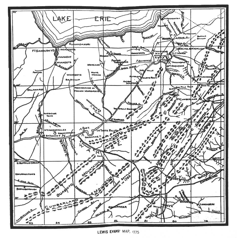
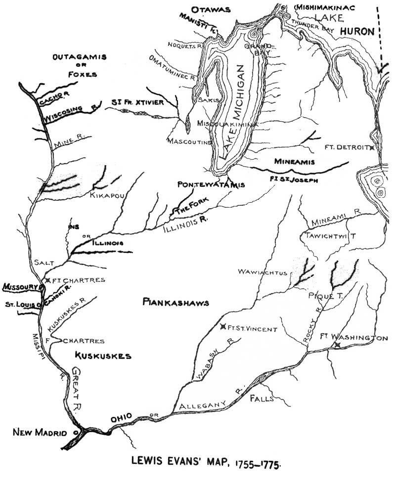