and from the same book pages 9-12
Rochester is situated on the 71st meridian west of Greenwich. The
village is about one mile east of this meridian, and in latitude 43° 18’
north. The town is approximately a trapezoid containing about 52,000 acres,
with its diagonals extending nearly ten miles north and south, and a little
over eight miles east and west. Its northeastern boundary is the state line
on the east bank of the Salmon Falls river which separates Rochester from
Lebanon and Berwick in Maine. On the southeast it is bounded by Somersworth
and Dover, on the southwest by Barrington and Strafford, and on the northwest
by Farmington, touching Milton for a short distance between Farmington and
the river.
transcribed by C Parziale
ROCHESTER: CHAPTER I.
Of natural ponds or lakes Rochester is almost entirely destitute.
The line between Rochester and Farmington crosses Ricker’s pond near its
center; and a small portion of Round pond extends over Barrington line.
"Little Long pond" also crosses the same line about half a mile farther east.
The Salmon falls river flows along the northeastern side, and the Cocheco
river crosses the town towards the southeast from Farmington to Dover.
Isinglass river (probably named from the mica in its bed or along its banks)
loops into Rochester from Barrington, making a large ox-bow, where it is
crossed by the Nashua & Rochester railroad; then returning to Barrington it
bends back again across the line and enters the Cocheco near where Rochester
corners on Dover. Owing to the level surface of the town the brooks are few
and of little importance. The principal ones are Robert’s brook, flowing
from Ricker’s pond; Berry’s brook, which supplies the reservoir recently
built; Willow brook and Heath brook.
Bowlders are not unfrequent, but none of remarkable size have been
observed. Coarse glacial drift and finer modified drift deposited by rivers
of the Champlain period, cover most of the town, forming extensive plains
which obscure the underlying rock. These plains extending for eight miles
along the Cocheco, are in many places, as especially at Gonic, underlaid by
clay. Their height at Rochester Village is two hundred and twenty-six feet,
and at East Rochester and Gonic two hundred feet, above sea level. The
river falls much more rapidly than the plains, so that it lies seventy-five
feet below them in the south part of the town. There are five "lenticular
hills" in Rochester. The finest of these is the one now owned by Walter S.
Hussey.
It rises with a very regularly rounded outline one hundred and fifty
feet above the lowland or valleys which surround it on every side. Another
of similar height but less typical in form, lies one mile southeast near
Gonic Village. Two of these occur east of the Cocheco, being Haven hill
crossed by the road to Great Falls, and Gonic hill a half mile south. The
former is less steep and prominent than usual, but was shown by a well at its
top to be composed of glacial drift at least forty feet deep.
Dry hill lying near Barrington, and the range toward Farmington
called chestnut hills, are probably the highest points in town, being a
little over five hundred feet above sea level.
The most important natural feature of the town is undoubtedly the
peat bog already mentioned. A large portion of it lies between the village
and the first crossing of the Great Falls & Conway railroad. The greatest
depth found in building that road was a little over twenty feet. East of the
railroad there are fifty or sixty acres more, varying in depth from five to
fifteen feet. A few persons have used this peat for fuel with good success.
It yields a large amount of light, dusty ashes which are found useful for
polishing. The market value of these peat beds depends almost entirely on
the price of coal. Largely through the exertions of Franklin McDuffee, the
Strafford county Improved Peat Company was organized November 13, 1866, at
the office of Nathaniel Wells, Esq., in Great Falls. The capital stock was
one hundred thousand dollars, all owned by less than a dozen men. D.H.
Buffum, A.A. Perkins, and Royal Eastman of Great Falls, E.G. Wallace of
Rochester, and Jeremiah Evarts of Boston were chosen directors; and Franklin
McDuffee treasurer and clerk. The company was not designed for stock
speculation but for business, fully intending to enter upon the work the
following spring, but so great a fall in the price of coal intervened that
they were compelled to abandon the enterprise. The land is still owned by
these men and their successors.
Evidently Rochester has superior natural advantages for manufacturing. With the Cocheco flowing diagonally through the town, and the
Salmon Falls forming its eastern boundary, our water privileges are rarely
surpassed. Its location also necessarily makes it a railroad center. It is
not possible that our great advantages should fail to excite a sure and
continual growth in manufacturing pursuits.
The soil of Rochester is largely sandy or slaty, and not favorable
for the highest agricultural success. In some parts, however, it yields good
crops. The plains are easily tilled, and, with a large supply of dressing
frequently renewed, will well repay the diligent farmer. The soil is
specially favorable for pines. White Pines, pitch pines, and Norway pines
have always abounded. These with several varieties of oak, hemlocks,
chestnuts, birches, maples, and larches are the principal trees. Shrubs and
smaller plants are such as are usually found in the light soils where pine
and white oak prevail.
Formerly, here as elsewhere, wild animals were numberous. Wolves,
bears, deer, and moose fed or annoyed the early settlers, and busy beavers
built their curious dwellings along the streams. They are now only
traditions of the remote past. The level country affording no rocky
hiding-places, these larger wild beasts were sooner exterminated here than in
many other places. The forests also being early cleared away, no shelter is
left even for the larger birds. For the same reason, foxes and raccoons are
fewer than in most New Hampshire towns. Mr. William N. Hastings, who has
made a special study of microscopic objects, has found diatoms of forms
apparently somewhat rare, such as are assigned by other investigators to
distant localities only. On the whole, it must be said that neither the
fauna nor the flora of Rochester presents any remarkable features.
ROCHESTER - in Strafford county, was incorporated in 1722, and contains 2,118
inhabitants; bounded N.E. by Salmon fall river, which divides it from Lebanon, (in Maine),
S.E. by Somersworth and Dover, S.W. by Barrington, and N.W. by Farmington and
Milton, comprising 26,609 acres. Cochecho river flows through this town from N. To S.
and receives Isinglass river near Dover line.
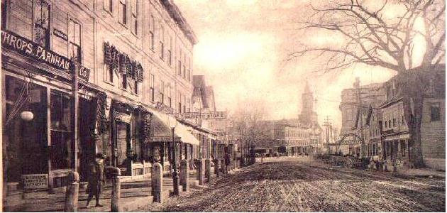
Near the centre of the town is a village called Norway plains, containing a meeting
house, a court house, about 40 dwelling houses, and several stores. There are also in this
town 4 grain mills, 4 saw mills 2 carding machines, and a cotton factory.
One term of the district court of common pleas is held here annually.
Rev. Amos Maine was ordained in this town in 1737. His successors have been
Rev. Messrs. Hill, Hall, and Haven the latter of whom is the present pastor.
In 1746 and in 1747, the Indians made excursions against this town in small
parties, committing many depredations and some murders.