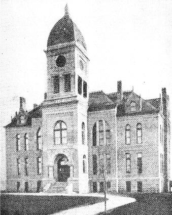
Murray County Court House, Slayton, Minnesota
Built 1902. Cost $22,300.00
Officers elect for 1947
Auditor.................Claire D. Peterson Judge of Probate..........G. T. Kolander
Treasurer.....................John Knutson Surveyor...............................Ole Ford
Register of Deeds...L. C. Christensen Coroner....................Dr. W. D. Maher
Sheriff........................Geo. L. Nelson Clerk of Court................Fred Helweg
Attorney.........................J. T. Schuler Supt. of Schools............Audrey James
County Commissioners
1st Dist. Geo. W. Hafner
2nd Dist. H. J. Carlson
3rd Dist. Chas. F. Sierk 4th Dist. J. E. Shirley
5th Dist. Archie McHarg
—4—
WESTERN MURRAY COUNTY HISTORY
This area known as Western Murray County was visited by
white men in 1688. In that year J. B. Franquilen charted and
mapped the Des Moines River as it is now known, as "The R.
DesMoingona." He mapped the river to its source and in so
doing must have passed through Leeds and other townships as
the Beaver Creek is the true source of the Des Moines. Fifteen
years later another Frenchman, Guillaume DeLisle, whose
records state, charted and mapped the river to its source. Maps
of these explorations still exist in Paris, France.
White men are supposed to have visited this section again in 1701. Le Sueur was investigating the alleged copper deposit in what is now Blue Earth County. Records show that he went on a big buffalo hunt west of the Minnesota River and as this section was a favorite hunting ground, it was assumed that they got their four hundred buffalo along "Buffalo Ridge" first known as "The Coteau Des Prairies."
There was a lapse in Murray County History until 1833 when the American Fur Company built a trading post. The post was named Crooked (Big Sioux) River Post by Indian agent Taliaferro. Bailly, agent for the fur company, used that designation but Joe Laframboise who was in charge called it "Grande Lisiere."
Joseph Laframboise, one of the best known traders during the American Fur Company regime, directed the building of the post which was located east of the Bear Lakes at the isthmus. He remained there as long as the post was in operation. A log cabin served as a store for trade goods and as a warehouse for pelts. Another small cabin was the living quarters of Laframboise and his family. A crude shelter for horses and several small buildings were also built. The two log buildings were surrounded by a high stockade. Voyageurs attached to the post dwelt in lodges near by, with the Indian women they took as wives. Over the stockade flew the flag of the United States, flown to remind the Indians that they owed allegiance to the United States and not to Great Britain.
The Grande Lisiere post was the first civilized habitation in what is now Murray County. More than that, it was the first
—5—
Previous Page
Next Page
Table of Contents
Index of Names
Home